
III. The Geology of the Cape Peninsula
The images below show the basic topography of the Cape Peninsula from Table Bay looking south over Cape Town and Table Mountain towards the Cape of Good Hope. The particular features are the Table Mountain massif and the chain of mountains that runs down the spine of the peninsula. Table Mountain rises 3,558 feet (1,085 m).
To the left of the mountains is the broad expanse of the Cape Flats that joins the peninsula at Muizenberg.
In the front of the image is Table Bay and Cape Town Harbour. To their right is Green Point and the polo-mint surrounded-by-green that is the spectacular Green Point Stadium built for the 2010 FIFA World Cup. Behind this is Signal Hill and Lion's Head and the west coast suburbs of Camps Bay and Bakoven.

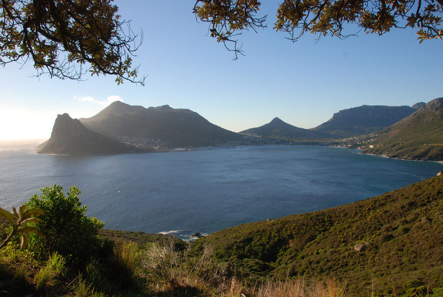
The topography of the penisula is brought into sharper relief in the aerial view below that shows the tremendous bulk of Table Mountain and the right fork of the mountains running down to Hout Bay and the Chapman's Peak Drive (see Driving Chapman's Peak). To the left the mountains snake down through Constatia (see Wine and Land I) and the wine country on the eastern slopes before meeting False Bay at Muizenberg. Beyond is Simon's Town bay (see Birds I: African Penguins) and the steep eastward facing slopes, from where we saw the dolphin and gannet feeding frenzy (see Mammals VI: Dolphins), between Simon's Town and Smitswinkel Bay. Beyond are the lower hills that run out to the cliffs at Cape Point.

The image below gives a schematic representation of the geology of the peninsula. The oldest rocks are the late-Precambrian Malmesbury Group made up of alternating layers of dark grey fine-grained greywacke sandstone and slate. These underly most of the peninsula.
Next are Peninsula Granites which were intruded as a huge batholith into the Malmesbury Group about 630 million years ago as molten rock which then crystallized deep in the earth. It has since been exposed by prolonged erosion and can be seen at places such as Boulders Beach at Simon's Town (see Penguins). It was also quarried from the base of Table Mountain by a Cornish quarryman (see Gone Bulawayo on the Cornish in South Africa ) for the construction of the Rhodes Memorial (see Rhodes Memorial ) on the edge of Cape Town.
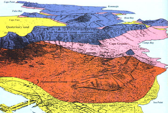
The Table Mountain Group sandstones - blue in the image) were deposited onto the eroded surface of the granite and Malmesbury basement.They are made up of two formations:
- The lower Graafwater Formation (300-450 m thick) consists of interlayered pale brown sandstone, laminated pink siltstone and dark maroon coloured shale.
- The Peninsula Formation (800-1500 m thick) consisting of hard, light grey coarse pebbly quartz sandstone, dominates the steep mountain cliffs. It was originally deposited as migrating sand bars in broad river channels.
The yellow areas represent Extensive sands laid down during the Pliocene and subsequent Pleistocene ice-ages between 2 million and 15000 years ago when sea-levels fluctuated between -120 to +200 m from present mean sea level. At times the sea covered the Cape Flats the Cape Peninsula was then a group of islands.
Each of the rock and sand types listed above is associated with different fynbos types which have different characteristic plants. The sands give rise to a variety of sand and sandveld fynbos types. As do the granites, sandstones and Malmesbury slates and shales. Topography and orientation also play a part - for example there is a 3000+ ft elevation difference between the top of Table Mountain and Buffels Bay near Cape Point. Similarly there are great differences between east and west facing slopes - the west get the colder winter westerlies whereas the easterlies get the warmer south-easterly trade winds. Water avalability is also crucial - wetter ground will abound in restios while dry sands may only be able to support succulents and bulb-rooted plants.