
III. The Milford Road: Economics and the Gondola Option

Milford: A key New Zealand tourism 'drawcard'
In 2005 the Tourism Industry Association of New Zealand stated in a submission to the Department of Conservation hearings on the Draft Fiordland National Park Management Plan:
Tourism is now New Zealand’s largest single foreign exchange earner and overseas visitors spend over $6.5 billion pa in New Zealand. One in ten New Zealanders is employed in the industry ... Tourism contribute[s] $16.5 billion to New Zealand’s GDP (9.6% of total GDP). Milford Sound is an iconic tourist attraction and a major drawcard for New Zealanders and international visitors. ... The [Fiordland National] park has been associated with more than 100 years of tourism development with substantial capital investment that has contributed to its iconic and recreational value.

The number of tourists attracted to Milford Sound each year has been growing rapidly. Milford/Piopiotahi visits rose from 247,000 in 1992 to 470,000 in 2004/5 season (out of a total of 650,000 visits to the whole Fiordland National Park).
By far the most frequent visitors are on organised tours with 69% arriving by coach 'which is regarded as being safer than attempting the road on your own' (Fiordland National Park Management Plan, 2007 pp. 100/154).

In 1990 the peak daily vehicle counts were about 300 vehicles each way (which are in effect the same vehicles, Milford Sound being an 117km cul-de-sac). By 2004 this figure had increased to more than 530 per day (FNPMP p.104).
In 2011 the average daily traffic was 620 vehicles a day but this rises to 820 vehicles a day in the peak summer weeks (Environment Southland: Assessment of Access Options for Milford Sound, November 2012). That doesn't seem a lot over a 73 mile road but the traffic tends to come in clots for the morning boat rides. And it can get pretty congested at the roadside stops along the way.

The Milford Road is one of the more dangerous public roads in New Zealand, with injury crash rates around 65% higher than the rest of New Zealand's network, and a fatality crash rate of almost twice average (per vehicle kilometre travelled), making it in 2008 the third most dangerous section of New Zealand's State Highway network.
There were 5 fatalities and 31 serious injuries on State Highway 94 in the decade 1992-2002. (There is an 85 mile section of SH94 - Te Anau-Gore - that is not part of the
Milford Road). We were advised by some friendly neighbours on the Otago Peninsula to take a coach to Milford Sound but thankfully we didn't.

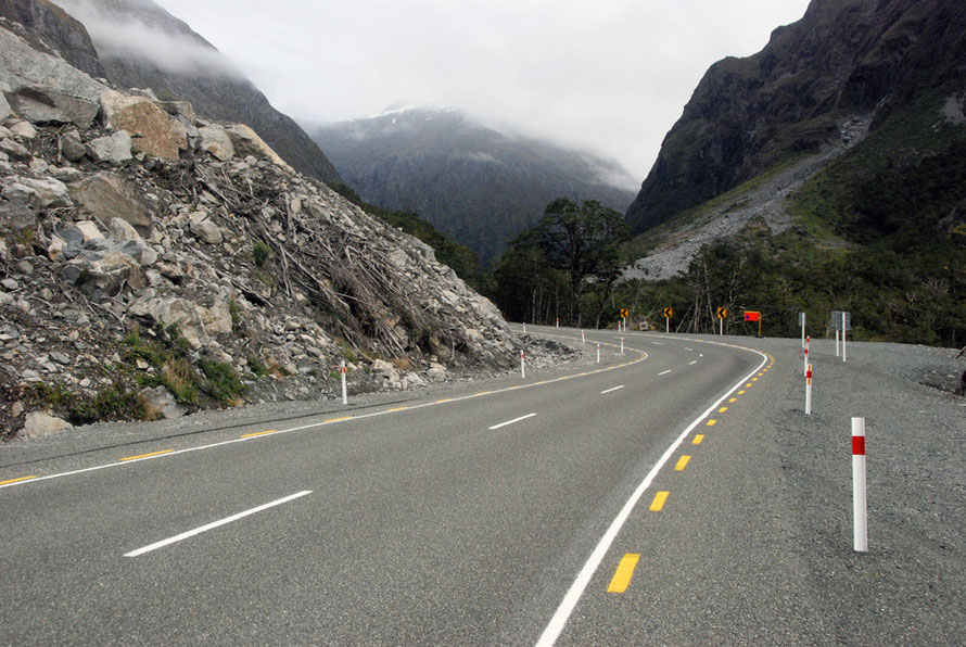
The road is prone to rock and snow avalanches (it is crossed by 40 avalanche paths) and helicopters drop explosives on snow accumulations perched above the high rocks walls in the winter (particularly those around either end of the Homer Tunnel which is fitted with massive avalanche guards. (See New Zealand Engineering February 1, 1986 p.18-21 on a new avalanche warning system for Milford Road.
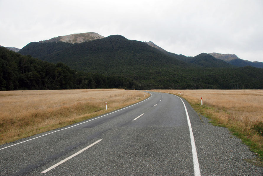
You can see why it is a dangerous road - there are long straights and sweeping curves in the Te Anau to Knobs Flat section which are great for high-speed head-on collisions with all the frustration of being stuck behind 'gawpers' and 'frequent photo stoppers'.
Then the road narrows and is funnelled through thick forest with poor visibility and frost traps and massive roadside tree trunks for smashing into.
The road down from the Divide and Pop's View is steep and will catch the unwary in their wrong-hand drive hire cars and vans. It then moves up the narrow winding section to the Homer
Tunnel. There is more of the same until Milford and the unlit, wet, uneven tunnel where avalanches pose their own threat.
We saw one campervan in a ditch on our way in. It looked careless rather than serious.
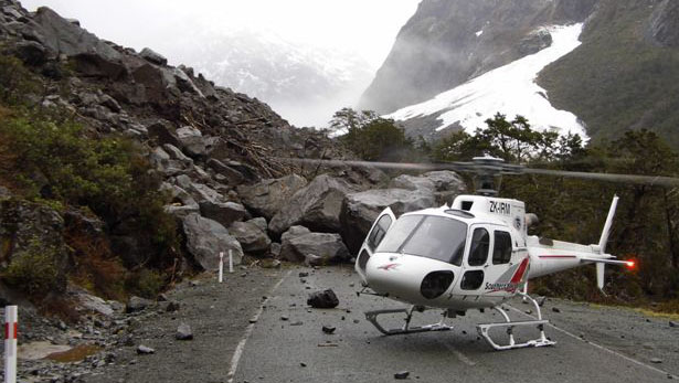
'The number and magnitude of these young landslides show that Fiordland has an extremely high rate of landslide activity, and the landslide hazard is also extreme.' These are most often triggered by earthquakes, which are also common in Fiordland (see Turnbull et al. 2010 Geology of the Fiordland Area GNS Science p. 81).
You can imagine people driving off the road and into traffic, being terrified into crashes by the convoys of hurtling coaches, and snow, ice, fog, torrential rain, falling rocks and severe
electrical storms all have a part to play.
The road is also a route to lots of rock climbing, kayaking and tramping venues and the outdoor fraternity is not always known for its caution on the roads. There are also an awful lot of campervans and young drivers - cars and campers can be hired by 20-year-olds in New Zealand with little driving experience.
Future Plans: gondolas and Monorails?
The prescribed round trip of 574km/6hr 38min (Google Maps) from Queenstown would be exhausting in a car and there are well known instances in the South Island of young international visitors with almost no driving experience wiping out other drivers and motorcyclists. (See NZ Herald 2014 here for a driver with almost no driving experience whose 'careless driving' killed two motorcyclists and seriously injured a pillion passenger).
A recent study by Venture Southland envisages a move to instigate a Booking System followed by a formal Park and Ride or Transit system. This study also raised the spectre of a gondola or monorail route to Milford from Queenstown which has caused huge consternation amongst environmentalists ( Milford Sound Transport Issues and Options Report - undated but probably 2005/6).
On the gondola issue that was initially proposed by Skyline Enterprises Ltd and Ngai Tahu Holdings (see my page on Ngai Tahu Holdings here) in 2001 (see this press report from 2012 and the Environment Southland report that backed the Gondola scheme in 2012).

This report was 'damned as flawed' by local politicians and advocates of other routes to Milford - see The Southland Times.
In March 2004 the NZ Herald reported that,
'A $100 million gondola project to link Queenstown and the Milford Sound is inching closer to reality but, if approved, is still five years away.'
The journey would use ferries from Queenstown to the gondola head and then cabins seating eight people and later in the journey passengers would transfer into the more robust 'funitel cabins' which hold 24 people each.
Barry Thomas, chair of Skyline Enterprises, is quoted as saying the cabins would, "blend into the vegetation", the system would be silent and cut three hours off the round-trip time from Queenstown.
(See here for the monorail proposal to Milford. This was rejected by the Minister for Conservation in May 2014.)
A proposal to build a toll road from Haast to Hollyford is still on the table at July 2014.
(For the Milford Sound travel options debate see Save Fiordland and see this Australian link that has lots of opinions and material.)
An update from Save Fiordland (personal message) of August 2014 states:
The two projects that have been rejected formally are the monorail and the tunnel. The gondola project ... went through a variety of investigations and was parked. It may raise its head again at some stage, but it has not entered any formal processes to date.

A tsunami threat?
A little known aspect of the whole Milford Experience is that it is potentially threatened by a tsunami that could be triggered in the Sound by a massive rockfall loosened by a large earthquake. There is more on this on my Rock, Ice and Preservation page in this section.

Tsunamis and more localised seiche (a standing wave in an enclosed or partially enclosed body of water) are a high risk in Fiordland. 'A major rock fall into any Fiordland lake could have potentially disastrous results for lakeshore constructions and their occupants.'
Similarly underwater earthquakes along the Puysegur subduction zone could trigger rapid 4m-high tsunamis. Catastrophic damage would only be likely where the fiord coast is settled - places like Milford Sound, West Arm and Deep Cove (see Turnbull et al. 2010 Geology of the Fiordland Area GNS Science pp.83-4).