
New Zealand's Recent Geology: Plates, Faults, Ice, Quakes
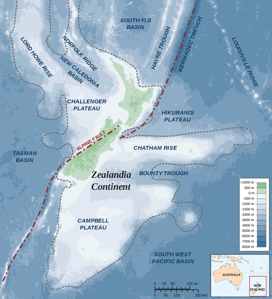
New Zealand's Alpine Fault
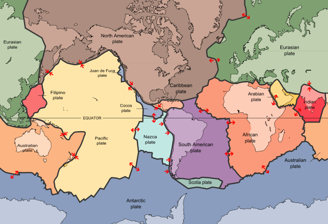
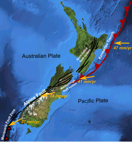
New Zealand (and the broader continental shelf area of Zealandia) sits at the meeting of the Pacific and Indo-Australian plates.
In the south-west, the Pacific Plate has a complex but generally convergent boundary with the Indo-Australian Plate, subducting under it north of New Zealand forming the Tonga Trench and the Kermadec Trench.
The Alpine Fault marks a transform boundary between the two plates, and further south the Indo-Australian Plate subducts under the Pacific Plate forming the Puysegur Trench.
The southern part of Zealandia, which is to the east of this boundary, is the plate's largest block of continental crust.
http://en.wikipedia.org/wiki/Pacific_Plate
The Alpine Fault is a right-lateral strike-slip fault and runs almost the entire length of the South Island.
It is classed as a transform fault or boundary.
This is a type of fault whose relative motion is predominantly horizontal. That is one plate is not slipping under the other but they are sliding against each other.
Transform faults usually end abruptly and are connected on both ends to other faults or subduction zones.
To the north of New Zealand the Pacific Plate is moving north and sliding underneath the Indo-Australian plate, creating the Kermadec Trench in the process. This achieves a maximum depth of 10km and is 5km deep when it joins the mud-filled Hikurangi Trough. To the south-west of New Zealand the Indo-Australian plate is sliding beneath the Pacific Plate.
The 850km-long fault is remarkably consistent in producing major (magnitude 8) earthquakes and on average ruptures every 330 years, at intervals ranging from 140 years to 510 years.
http://en.wikipedia.org/wiki/Alpine_Fault
http://www.teara.govt.nz/en/sea-floor-geology/page-5
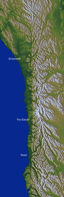
'Over the last 45 million years, the collision has pushed up a 20 km thickness of rocks on the Pacific Plate to form the Alps, although much of this has been eroded away. Uplift has been fastest during the last 5 million years, and the mountains continue to be raised today by tectonic pressure, causing earthquakes on the Alpine Fault. Despite the substantial uplift, most of the relative motion along the Alpine Fault is sideways, not vertical.'
'These two plates are moving against each other at the Alpine Fault. The east side is being pushed up to make the Southern Alps, with the Alpine Fault at the base of the mountains from Milford Sound to Blenheim. The west side is moving northwards, and has carried rocks nearly 500 km from Otago to Nelson.' (University of Otago:Dynamic Collision)

It is reckoned that at least 15 kilometres of rock have been eroded from over present-day Otago. All that remains is the widespread alluvial gold and small amounts of gravel (University of Otago)
The Southern Alps are curretnnly being uplifted at a rate of 10mm a year and eroded at pretty much the same rate. (University of Otago:Golden Rivers)
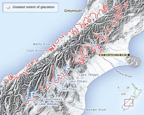
The Pleistocene Ice Ages
The Pleistocene period lasted 2 million years and was characterised by 100,000 year cold/warm cycles of that gave rise to widespread glaciation. Furthermore in New Zealand the ice ages began just as the mountains had reached their maximum hieght.
The last period of glaciation was the Ōtiran which peaked 20,000 years ago and ended 10,000 years ago. Average temperatures were 4.5C below current ones (see Gibbs, Ghost of Gondwana p.134).
The map below shows the extent of glaciation in part of the Southern Alps. Sea levels were much lower due othe water being captured as ice and the landmass of New Zealand was consideerably larger at this time.
Earthquakes
New Zealand records 20,000 earthquakes a year on average, of which 200 can be felt. The cities most at risk are Wellington, Hastings and Napier which are near the active subduction zone of the Kermadec Trench.
Major earthquakes along the Alpine Fault are less common.
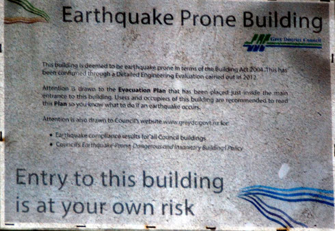
New Zealand has strict building regulations. In Hastings and Napier building cannot be more than 5 stories high.
The Marlborough quake of 1848 casued much damage in Wellington and prompted a major shift away from brick and masonry buildings to wooden construction. The massive 8.2 magnitude Wellington quake in 1955 did comparatively little damage as a consequence.
http://en.wikipedia.org/wiki/Earthquakes_in_New_Zealand
NB In the Shaky Isles maybe low, wooden, light buidlings are a much safer option than double-storey brick and stone buildings with heavy slate or tile roofs.
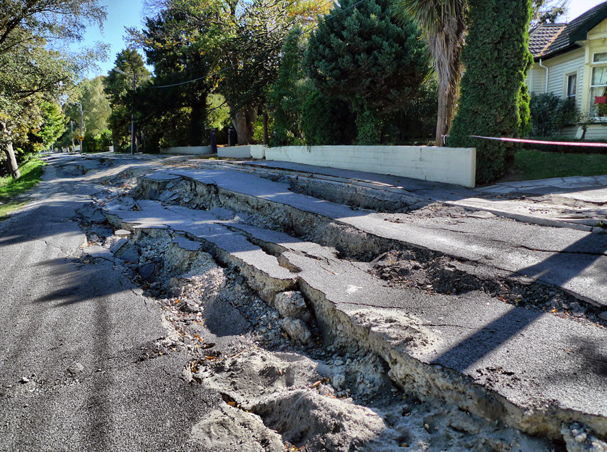
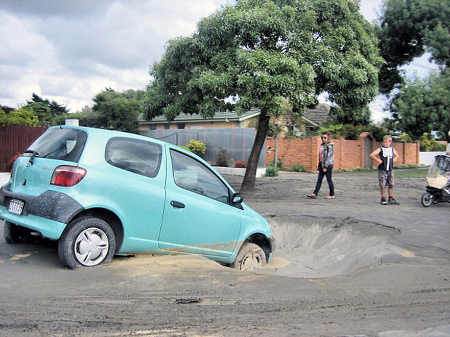
In September 2010 and February 2011 Christchurch, New Zealand's secomd most populous building was hit by powerful earthquakes - 7.1 and 6.3 respectively.
The second was characterised by particular violent upward movement which exceeded expectations built into building regulations. It has been described as
beyond 'maximum considered events' (MCE). Buildings had already been weakened by the 2010 quake and major destruction occurred and 185 lives were lost.
By April 2013, the total estimated cost was estimated at NZ$40 billion and some economists estimated it would take the economy 50 to 100 years to completely recover.
http://en.wikipedia.org/wiki/February_2011_Christchurch_earthquake
To go to Martin Luff's full photoset of the Christchurch quakes click here or on photos above.
Earthquakes and Westland Forests
In the last 650 years, these episodes [major earthquakes] have occurred often enough (every 100-200 years), relative to the longevity of the major canopy trees, that they exert a dominant influence on the present forest structure.
Consequently, over 50% of the study area comprises simple-structured, even-aged forests composed of first-generation trees established after major erosion or sedimentation events.
(From Wells, A. Duncan, RP and Stewart, GH (2001) Forest Dynamics in Westland, New Zealand: The Importance of Large, Infrequent Earthquake-Induced Disturbance. Journal of Ecology, Vol. 89, No. 6 p. 1015.)
This helps explain to characteristics of Westland forests - the stands of mature conifers without younger and middle-age trees - (large scale even-aged cohort regeneration takes place after major earthquake events) - and the rata and kamahi stands on steep front ridges of the mountains. It is likely that a lot of these stands developed after a major Alpine earthquake.
With regard to the latter this may help explain widespread dieback recorded in Westland forests.
Trees growing in a regionally extensive, even-aged cohort that developed after major region-wide disturbance would senesce at about the same time, thus becoming susceptible to widespread synchronous dieback from a triggering factor such as possum browse (p. 1016).