Glaciers 1: The Geomorphology of the Fox Glacier Region
An old land with a young landscape
New Zealand is an old land with a young landscape.
The Southern Alps and Fjordland are some of the most dynamic landscapes in the world and in geological time, have exceedingly young landforms.
The great glaciers and ice sheets of the Ice Ages pretty much obliterated everything in their path and most land surfaces between the Main Divide and the Tasman Sea are less than 20,000 years old.
Indeed, it is only the continued rate of mountain uplift that reproduces the Southern Alps under such intense processes of destruction and erosion.
The Ice Ages swept away the beech forest that once covered most of the South Island and in the Westland gap they never were to return, beaten out of place by the rata forests that (spread by birds) took over from the slow wind-spread heavy seeds of the beech.
It is a landscape that seems to be changing, forming and deforming in front of your very eyes. And indeed it is.
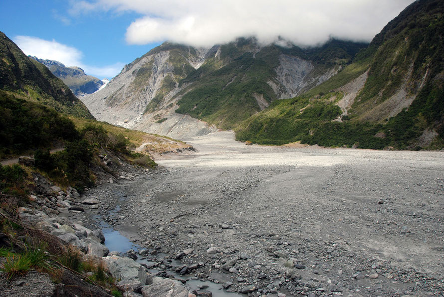
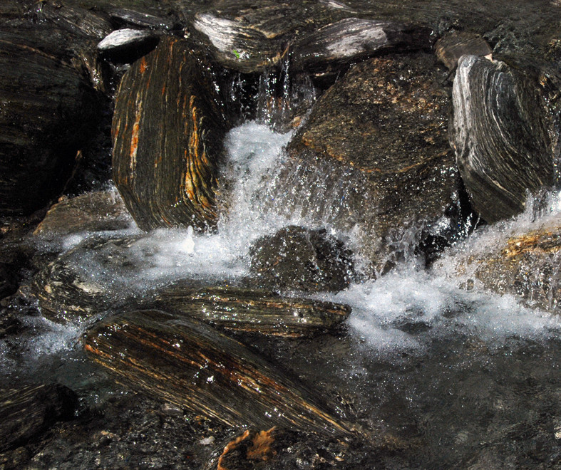
The Fox Glacier grinds forward at 4-6 metres a day. The rainfall of up to 14 metres a year and its multiplied snow yield results in the massive erosive power of the rivers and mountain torrents.
And despite the temeprate climate cold air sinks from the mountains in the winter giving freezing montane conditions in the valleys hidden from the winter sun.
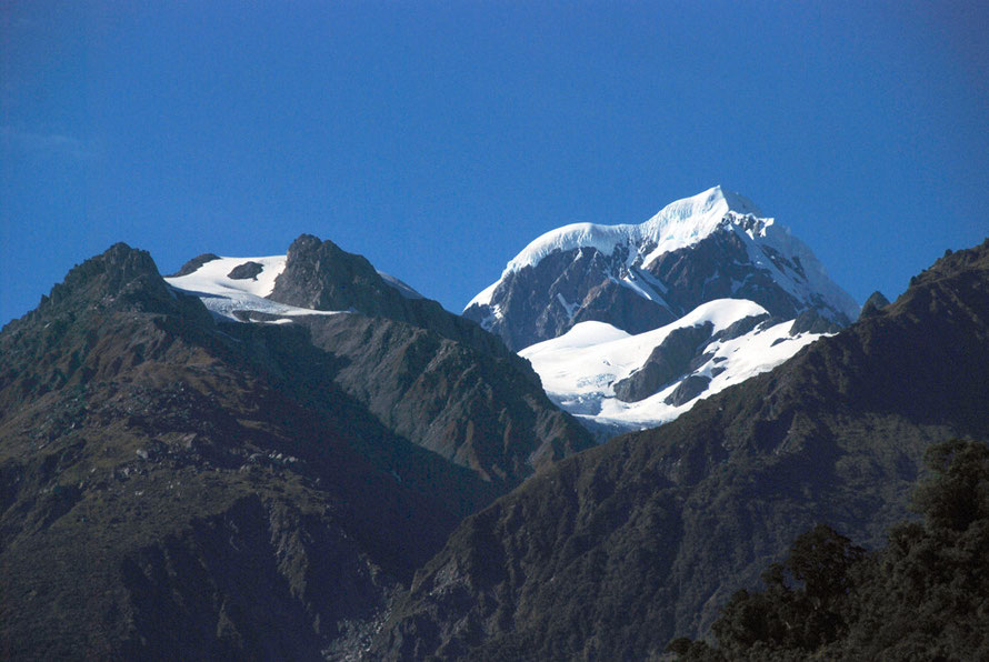
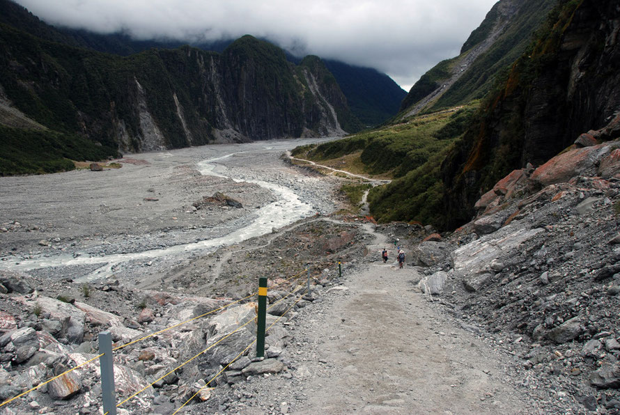
One of the striking things about the Fox Glacier is the sense of the world being made anew by titanic and unstoppable forces. But as it is difficult to get a sense of the physical scale of these forces so is it hard to understand the timeframe in which they work.
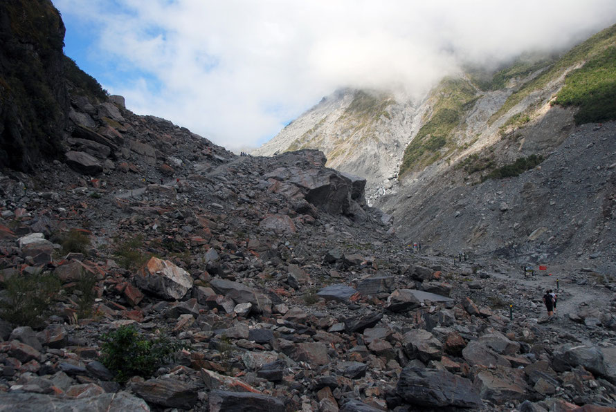
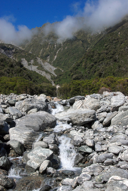
Below in this section you can see the destruction wrought by a glacier at work. It's a familiar enough scene to anyone who has spent some time in upland areas but for me the shock was the newness of it all.
The landscape is completely denuded. The rocks and dust and debris look freshly minted. Even hundreds of feet above the glacier it feels as if the glacier only just recently passed by crushing and gouging, smashing and ploughing, and depositing and layering.
Trying to make sense of it all is not easy. The language of contemporary geology has become so complicated and detailed that lay readers are likely to bemused. And yet the 'guides to glaciation' run out of explanatory power once they have gotten beyond the 'masses of ice moving downnhill' mantra.
So I've spent a bit of time trying to make sense of it all. How long has the Fox Glacier been at work and how can we understand the forces driving it?
Timescale
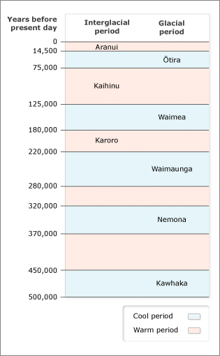
The Fox Glacier has presumably been doing its thing in one configuration or another since the start of the first ice age in New Zealand - that's about half a million years.
During the Ice Ages the ice over the Southern Alps would have, of course, been much thicker (500m over the highest peaks) and more extensive than its present sporadic cover.

Even within the last two hundred years there has been considerable difference as the Fox terminus has retreated a good 2km following the c.1890 peak of the last of the glacial advances of the “Little Ice Age”.
In that same period the mountains have been rising inexorably due to the tectonic forces of plate movement along the Alpine Fault (see my page The Shaky Isles).
At 12mm a year that is an uplift of 6,000 metres (6 km) over a half million years.
In the longer term it is reckoned that 'over the last 45 million years, the collision of [the Australian and Pacific plates] has pushed up a 20 km thickness of rocks on the Pacific Plate to form the Alps' (en.wikipedia.org/wiki/Southern_Alps.)

Retreat of the Franz Josef glacier 1950-65


Making Mountains - the Alpine Orogeny
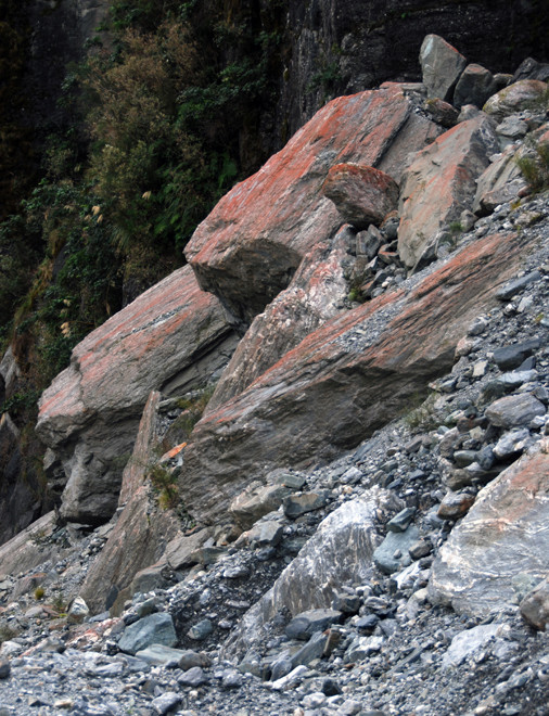
Of course, such massive forces do not create a 'serene' uplift, as if being raised by a forklift truck. This is solid rock we are talking about and tectonic movement along the Alpine Fault in the Fox Glacier region has led to intense folding along northeast/southwest axes which in turn has led to major faulting at right angles to the fold movement.
This folding and faulting creates areas of less resistance in the mountain morphology and the forces of erosion quickly pick these out and exacerbate them.
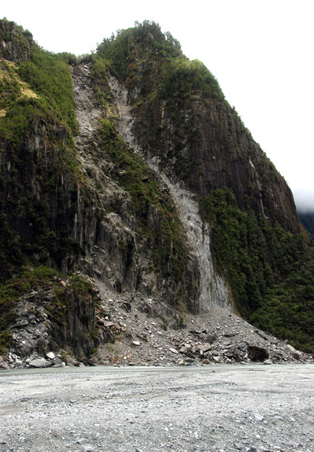
The spectacular sheer wall of Cone Rock, which rises 300m vertically from the lower Fox valley floor marks the line of a fault created by mountain folding and higher up the valley the tongue of the glacier runs between one fault under Chancellor Ridge and another on the further side of the glacier. (see BM Gunn, Structural Features of the Alpine Schists of the Franz Josef-Fox Glacier Region, New Zealand Journal of Geology and Geophysics May 1960.
Faults and Folding
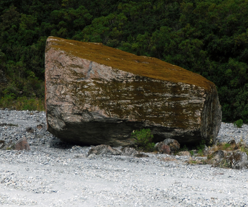
These vertical faults and the bedding planes in the rock formations themselves allow the glacier to pull out huge boulders along the lines of faulting. That is, the glacier is working not against a mass of undifferentiated rock but a body of rock that has been fractured and that bears the marks of its own sedimentary creation.
And in one of those strange feedback loops the higher the mountains are elevated the more severe the weather gets: more freezing, more snow - and the more rampant became the forces of erosion determined to grind the mountains into the sea.
Although it is not only erosion that leads to the flattening of mountains. This also takes place by the melting of the continental crust beneath them - which gives them buoyancy - and they sink back down into the earth's mantle. This is a process governed by so-called isostatic equilibrium.

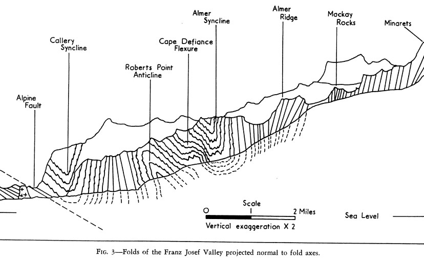
As far as I can tell back at the start of the 1960s the way in which the faulting in the Fox Glacier region was understood was fairly simple. Intense folding was seen to have led to lateral faults developing. But the way in which the uplift took place was little understood (see Diagrams 2 and 3 below).
An intense period of multinational geological exploration and experimentation in the South Island in the 1980s and 1990s sought to develop a more sophisticated understanding of the uplift process and the faults that ultimately generate earthquakes like the one that hit Christchurch with such devastation in 2011.
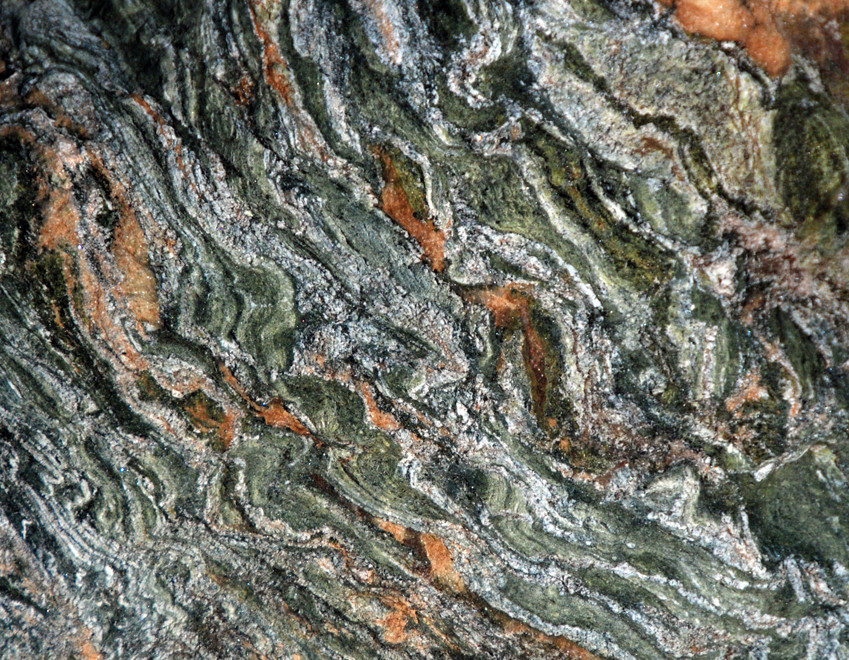
The Rocks of the Fox Glacier Region: Greywacke and Schist
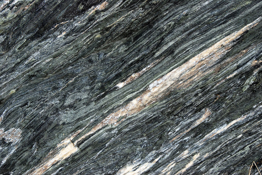
The rocks that make up the Southern Alps are largely greywacke - a mudstone - and semi-schists and schists.
The greywacke beds tip to the west at a steep angle of 15-40 degrees and have a minimum thickness of some 10km (see Gunn below p.290).
Semi-schists and schists underlie the greywacke beds (see the vertical section in the Diagram 4 below).

Diagram 4 above represents the layering of these rock types and their exposure to the west of the Southern Alpine Main Divide by uplifting at the Alpine Fault border). The Australian plate pushing below the Pacific plate and running parallel to it has brought the deeper strata of rock to the surface.
Again this is not a process that has been achieved by just a 'little bending'. Rather it takes place through intense folding, faulting and is accompanied by metamorphic processes working on the rock itself.
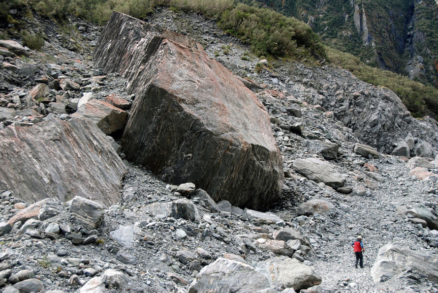

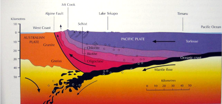
Diagram 5 above shows a geological cross-section for the Franz Josef region and is a good stand-in for the Fox Glacier. (The Fox and Franz Josef glaciers are about 20 miles apart). From this it is possible to see that immediately to the east of the Alpine Fault a massive section of the lower strata of rocks - the schists - has been tilted and pushed up by tectonic action.
Five kilometres to the east this section dramatically meets beds of greywacke. Through the whole section sloping vertical faults cut through the rock strata and intense localised folding and faulting is apparent where the dark-shaded schists butt up against the greywacke block of light-shading.
It is estimated the bedrock greywackes are 400-600m years old. The schists and some layers of greywacke are in the region of 150m years old.
Soils are rich in silicates and form quickly but are impoverished by leaching. The most fertile alpine soils are on the hill slopes where rejuvenation is constantly occurring through erosion processes. The alluvial flood plains contain the most fertile soils. Moraines, ridges, and terraces are very infertile (Westland Tai Poutini National Park Management Plan 2001-11 pp.30-1).
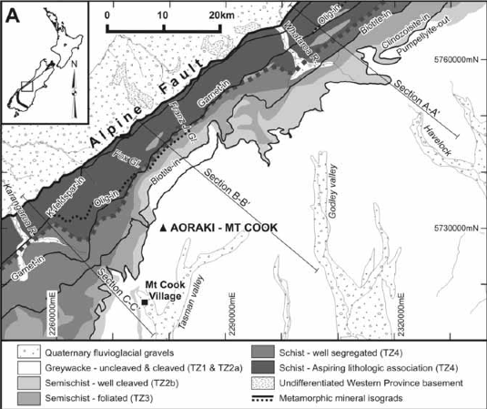
Diagram 6 shows the representation of the surface rock in the Franz-Josef and Fox areas. There is a rapid transition form greywacke to cleaved, foliated, and segregated schists to a schist with an 'Aspiring lithological association' - that is a schist occurring near Mt Aspiring and not a schist with 'aspirations to be lithological' - as I thought.
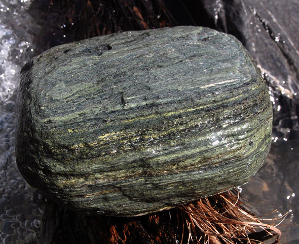
Schists themselves are metamorphic rocks that have undergone processes of heating and pressure and are characterised by 'shiny bits' that are 'medium to large, flat, sheet-like grains [of separated minerals] in a preferred orientation.'
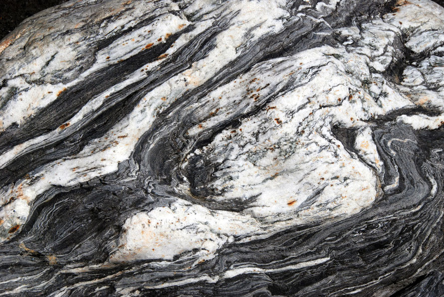
These can include micas, chlorite, talc, hornblende, graphite, and quartz (Wikipedia:Schist). Schists are very easy to split because of the grouping and orientation of their flaky mineral components.
The schists of the Southern Alps are derived from sandstones and differ according to the degree of metamorphic transformation that they have undergone.

Dynamic Metamorphism through plate collision
Schists tend to be created by regional or dynamic metamorphism rather than by contact metamorphism.
That is, they are not super-heated by contact with intrusions of molten magma into the rock but rather they are formed by the pressures created by their location - for example, through the weight of rock above them - or through the horizontal pressures and high temperatures and distortions caused by tectonic collision.
Such zones are known as 'orogenic belts' ("orogeny" Greek - 'oros' for 'mountain' plus genesis for 'creation') and their origins vary.
Those that create alpinotype mountains - the European Alps, the Himalaya, and New Zealand's Southern Alps - tend to do so through plate collision rather than subduction (which is more associated with volcanic activity - think of the Andes for example).

Diagram 7 above gives a better picture of the dynamic of mountain building in New Zeland - known as the 'Kaikoura Orogeny'. Starting 25MYA this originated in the collision of the Australian and Pacific plate.
This has continued since then and the last 5 million years have experienced the most rapid uplift, which continues to this day.
In Diagram 7 the Pacific plate is being pushed above the Australian plate but this is not a classical subduction process. Rather the plates are ramming into each other while at the same time moving laterally along each other. Rocks from the south west of the fault have been moved 480km northwards over a 25 million year period.
But as can be seen from the diagram crustal thickening has taken either side of the Alpine Fault through the collision forces at work. This thickening allows the west side of the South Island to support a greater mass of mountains than would otherwise be possible without the Pacific Plate sinking into the mantle beneath it.
The rocks in the section of Diagram 7 show the great mass of monotonous Torlesse Greywackes underlain by three layers of schist - chlorite, biotite and oligoclase. As these are pushed to the surface from 10+km down they are subjected to increasing horizontal pressure.
The deeper the rocks the more they have been metamorphised.
Veining and deposition within the metamorphic schists has been achieved through 'the liberation of metamorphic fluid during uplift'.
That is, the disturbance created by the uplift and faulting of vast transections of the earth's brittle and ductile crust has released the flow of super-heated water and brine that has dissolved and accreted mineral veins in the schist rocks by flowing along large and small faults (see NZGS 2003 p.18).
Greywacke is the basic constituent of the mountain ranges in of New Zealand's North and South islands. It consists of huge beds of muddy grey sandstone alternating with thinner layers of darker mudstone.
It is a sedimentary rock that was formed over 200MYA as vast fans of river-borne sediment were deposited onto the continental shelf of the ancient super-continent of Gondwana. This then intermittently cascaded down the deep-sea canyons as turbidity currents – in effect underwater avalanches - to create layers thousands of metres thick.
As the layers thickened they sank deeper into the earth's mantle and were exposed to growing pressure and temperature and were hardened to form the Torlesse greywackes that make up more than half of the New Zealand landmass.
From 200 million to 160 million years ago the huge beds of greywacke moved into collision zone of the Alpine Fault. This began to transform the base layers of greywacke as they were subject to increasing horizontal pressure and temperatures of over 300°C.
This transformed the Greywackes into three distinct types of schist and created the greenstone so treasured by Maori as pounamu (see Te Ara Geology).
Glaciers and Gold
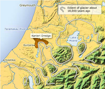
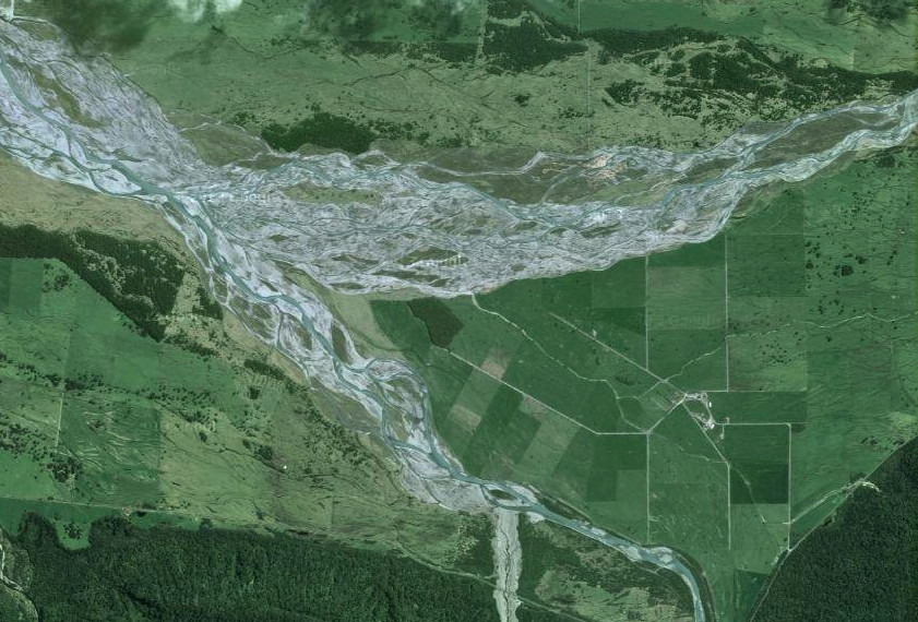
'During glacial periods a major glacier extended down the Taramakau River valley. This map shows the extent of the glacier in the later part of the last glaciation, about 18,000–20,000 years ago. Alluvial gold was concentrated in river gravels in front of the glacier, and one of the richest areas was near Kumara. .'
Source: R. P. Suggate and T. E. Waight, Geology of the Kumara-Moana area. Geological map 24. Lower Hutt: Institute of Geological and Nuclear Sciences, 1999