III. Along the Green Line: Nicosia to the East Coast
We'd arrived on the coldest day of the winter and the next day was no better. A bitter wind was blowing hard from the north-east but the sky was clear and the sun was shining. I set out from Nicosia to do a winding route to Cape Greko, not sure what I would find away from the coast. Flying over the area on the way into Cyprus one time it looked pretty bleak - low, marly, dry hills.
Leaving Nicosia on the N2 I turned to the left for Potomia, figuring that there would be water there 'potamia' meaning river in Greek.) The Green Line here strays way to the south through the Louroujina Salient, to take in the village of Louroudjina, once one of the most populous Turkish Cypriot villages on the island.
Potamia was a small little place. I immediately got a sense of something having left the village. There was that feel of dislocation, reinforced by one or two decaying mud-brick houses. Others, whitewashed, were brilliant in the hard, cold light. The village is very close to the Green Line. Had something happened here?

I turned round by a nice looking primary school where the kids and staff were out enjoying the sun, in a vigorous, running-around sort of way.
Later I learnt that Potamia/DERELİKÖY (meaning 'river' in Greek and 'village with a stream' in Turkish) was a mixed village. After the battle of Agios Sozomenos on 6th February, 1964 the entire population of Turkish Cypriots (about 330) fled the village for the Louroujina Enclave. Many returned in 1969 and then were displaced again in 1974. A few Turkish Cypriots remain and the village hosts many displaced Greek Cypriots from the north (see PRIO:Potami/DERELİKÖY). I
n 1960 the village had a population of 539. In the 2001 census it was 415. Agios Sozomenos, which was a Turkish Cypriot majority village a kilometre north of Potamia, is now deserted.

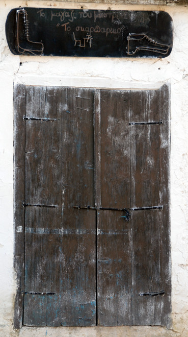
As I was driving through the village the second time I noticed a shuttered window and an old hand-drawn sign over it for a cobbler. Driving out of the village I came across a sign to an old Water Mill. I squeezed down a little road and pulled up under tall trees before verdant fields in a wooded-hollow with a farm at its head.
I do find it amazing the way the contrasts in Cyprus can still smack you in the face. I was only 15 minutes from Nicosia's very modern and sprawling suburbs and here was a village that seemed to come out of a distant past with a shop sign that should have been in the Folk Art Museum in Nicosia.
The stone-built water mill was impressive. I looked through large plate glass windows at dusty displays and old photographs about the harnessing of the water from the streams that flow from the Troodos but I couldn't make it out. The place had the feel of a half-finished tourist project that had run out of steam. Up above there was a big, empty stone-lined mill pond and a small thirteenth century church. Apparently the mill was used until the 1940s and known as 'Paleomylos' in the early middle ages. (See Fig. 13, C. Schabel and A .Nicolaou-Konnari (eds), 2005, Cyprus: society and culture 1191-1374).
It may be that this mill was part of a medieval sugar production plant owned by the Venetian Cornaro family (see below) which also owned sugar plants at Episkopi (see my page Sweet Salt: Sugar production in Medieval Cyprus).

It was recently announced that a major restoration project of the grand palace of Potamia, built during the Lusignan rule of Cyprus (1192-1489), is to take place.
The palace was often mentioned in historic chronicles as a pleasant royal residence with beautiful gardens. King Ianos (1398-1432) used the manor as a command centre for his Venetian military forces during the battles against the Mameluks of Egypt, who burned it down in 1426. It is believed the impressive manor was restored soon after and today’s structure is thought to be the one used by the last Queen of Cyprus, Caterina Cornaro (1474-1480). After the Ottoman conquest, new buildings were added and the manor became the command centre of a rich Turkish ciflik or landowner. It was last used, between 1964 and 1980, as a military camp for the National Guard. After that, the whole structure became unsafe and it is slowly collapsing.
The article above quotes Antiquities Department director, Maria Hadjicosti, who says that that Potamia is a bi-communal village, and that
'Potamia ... is, along with Pyla, the only community in the government controlled areas in which Greek and Turkish Cypriots were not affected by the Turkish invasion in 1974' (see Demetra Molyva in Cyprus Weekly, 7-13 October, 2011).
Leaving the area I passed a clementine grove, the trees groaning under the weight of fruit. I stopped in the middle of the road to take a picture.
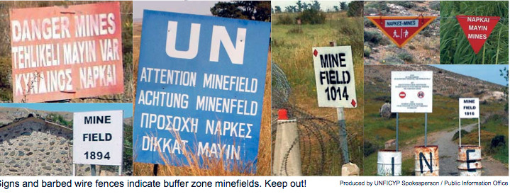
I then skirted round the back of Dali (site of the ancient kingdom of Idalion) and round the end of the Louroujina Salient which is up on top of a spectacular hill. I was heading down a shallow valley when I passed a sign that said - still- after all this time - 'Caution Minefield' in English and Greek.

Again those contrasts in Cyprus. The minefield seemed to be a rectangular enclosure behind two strands of barbed wire that backed up the slope to the cliff-like rise to the salient. I drove by and turned round and came back to take a furtive photograph.

In 2011 the UN announced the end of its de-mining programme in Cyprus, having cleared 27,000 mines from the buffer zone in the previous six years. This work has been carried out by de-miners from Mozambique and Zimbabwe, along with G4S Ordnance Management, a private company. One Mozambican team leader, Felisberto Novele, lost his life in a cleared minefield 10 kilometres from Nicosia.
The UN Mine Action Centre in Cyprus (UNMACC) estimates there may be 15,000 mines remaining in Cyprus. Work has come to a halt due to a lack of access to remaining minefields outside the buffer zone. The minefield I drove past was presumably one of these.
I drove through Lympia and then turned northward up the eastern side of the Louroudjina Salient. I took a side road to the right signposted to 'Ancient Tombs' - who wouldn't have?
It was a strange distended landscape, the rolling hills stretched out, not a person or car in sight, the north-easterly wind booming through the open valley. Towards the end of it a crest rose up and on it stood abandoned, decaying, crumbling buildings. I drove by, turned around and drove by again. I could see one or two cars parked amongst the gaunt, mud-brick houses.


This was, I later found out, the abandoned Turkish Cypriot village of Petrofani/Esendağ.
(Note: most Turkish Cypriot villages didn't adopt alternative Turkish names until the 1950s as the inter-communal conflicts intensified in the face of the Greek Cypriot anti-British 'enosis' - unity with Greece - campaign).
The village's 170 inhabitants fled in 1964 and again in 1974. They are now mainly concentrated in the village of Exometochi/Düzova in the Famagusta district in the de facto 'TRNC'.

Petrofani was already a village during the Venetian period and apparently abandoned and then reoccupied during the period of Ottoman rule. After its abandonment in 1974 farmers from Athienou began using the buildings in the village to shelter sheep, goats, and cattle.
Petrofani is a typical, nucleated Cypriot village where the,
‘style of architecture found in most of the buildings (where a stone socle supports mud-brick walls covered with plaster on the interior and exterior) shows remarkable conservatism and continuity with ancient dwellings’ (p. 324).

The buildings in Petrofani were “loosely packed” — there are open spaces between some of the household compounds — and the compounds were large, about 1,100 m2 (say 30m x 35m – which is about 4-times the playing area of a doubles tennis court).
The typical compound was enclosed by a mud-brick wall and included several buildings. The compounds were arranged in a “beehive” or “pueblo” fashion, with adjacent compounds often sharing common walls.
Household size was an average of five persons per household - slightly larger than the median size of rural households in the Cyprus census of 1946 (R. Yerkes 'Viewing the Past through the Present Ethnoarchaeological Studies of Population and Ancient Agriculture' in "Crossroads and Boundaries: The Archaeology of Past and Present in the Malloura Valley, Cyprus" 2011, eds Toumazou, M. et al. p.324-6).

It was a weird place on that wild, blowy day. I was close to the Green Line and had that feeling that I was being watched, that eyes were upon me. I felt very conspicuous out in the broad landscape. Having got my pictures I drove back to an even smaller turn-off that I figured must go to the 'Ancient Tombs' that had been promised.
This took me up another broad valley with green wheat fields stretching away to a horizon of twin, flat-topped hills. Along the verges grew abundant and ubiquitous stands of Small-Tree Mallow (lavatera cretica). I took another turning and after a kilometre passed what seemed an oasis in the fields of windswept green and arrived at a dusty empty car park raised up from the valley floor. When I got out there were the ever-present shotgun cartridges scattered around amongst the stones and even an brightly-coloured cartridge box in the tomb enclosure itself.

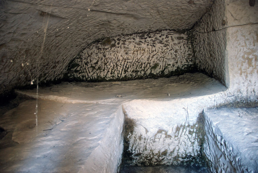
It was amazing to have the tombs to myself with no guardians or entrance fee. I opened up the green metal gate, half-expecting it to be locked. But it wasn't. The wind whipped across the valley but it was snug, if damp, dusty and spidery-webby down in stone-hewn tombs. I wandered from tomb to tomb, up and down the slippery steps.
The chamber tombs of Mağara Tepeşi/Malloura consist of four large tombs cut into a powdery, chalky limestone/marl that reminded me of the underground tufa limstone quarries in Loches on the Indre, tributary of the Loire, in Central France. But it was softer, chalkier.
The largest of the tombs, Tomb 27, had a stepped sunken forecourt, and a low room with a two-level stone bench cut round it.
Large numbers of artifacts were recovered from this tomb: silver and bronze coins, scraps of metal vessels and nails, gold and silver finger rings and earrings, a gold jeweled necklace, local and imported lamps, and ceramic vessels dating to the Hellenistic Greek-early Roman periods. The extent of these finds leads archeologists to believe that the tomb was used for generations by extended families of considerable wealth. An analysis of skeletal material found in Tomb 27 suggests that as many as 31 people were buried there over the years (see M. Toumazou at Davidson College).

Excavations further up the valley revealed a sanctuary that dates from the Cypro-Archaic period. This was discovered by a Monsieur M. de Vogüé, who lead a French mission in 1862.
The results of this excavation were never published, although some 70 sculptures in the Louvre have been identified as coming from Malloura. In later years, parts of the sanctuary were looted and hundreds of statues were exported illegally from Cyprus (see M. Toumazou above).
(See also my page, Buying and Selling the Past on looting by European and American collectors and entrepreneur/traders of Cypriot antiquities.)
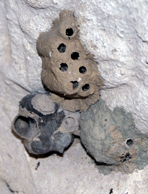
Inside one of the tombs were the cylindrical, barrel-shaped, mud-constructed homes of some kind of insect, probably a Mud Dauber Wasp.
In another, the groundwater had seeped up into the sunken forecourt. Toumazou (above) mentions a corbel-roofed water channel 0.5m wide and 1m high that extends eastwards 100m from Tomb 27 and a large cistern for water storage that was discovered near the tombs. Who knows what this great labour was designed to achieve but access to water in this landscape in the harsh summers would have been essential for any permanent settlement?
I later came across details of ethno-archaeological work at both the Romano-Medieval settlement of Atheniou-Malloura and Petrofani. The settlement of Atheniou-Malloura was 500 metres further up the valley from the Mağara Tepeşi/Malloura tombs, at the confluence of two streams. It is estimated that it had a population of 60-75 people in Roman times (ie from the 1st century BC) and 170-80 people in medieval times. It was abandoned sometime before the first census in Cyprus (1881).
The village followed the classic Cypriot lines of a nucleated village, with adjacent house/compounds from which the inhabitants would move out to work their pieces of land. The form of settlement developed for reasons of security, sociability and access to scarce water resources.
(See Yerkes, R., (2011) 'Viewing the Past through the Present Ethnoarchaeological Studies of Population and Ancient Agriculture' in "Crossroads and Boundaries: The Archaeology of Past and Present in the Malloura Valley, Cyprus" 2011, eds Toumazou, M. et al.)
I got back in the car and re-traced my steps towards Athienou which is bang up against the Green Line. Although only just over 10km from bustle and of Larnaca it seemed a different world. I wandered into the great concrete cavern of the town hall and museum without encountering a living soul and looked at the sparse antiquities in the gloom. Of course, the best ones from the ancient town of Golgoi, reputed to be named after Aphrodite's son, Golgos, and the sanctuary of Malloura, now reside by dubious permissions or none at all (having been, frankly, nicked) in the Louvre in Paris and the Metropolitan Museum of Art in New York. The sweepings as such were left for the unworthy locals to appreciate.

I tried to drive out of Athienou which is a mix of old, tight streets and new building that speaks to a growing sense of ease with proximity to the Green Line and the site of past trauma.
I got lost up a side valley full of little dairy farms, which abound in this part of Cyprus. I wondered how the cows survive the summers in their tin sheds when temperatures must top 100°F.
Presumably irrigation from aquifers that have not been exhausted or polluted with sea-water are utulised to grow intensive fodder crops like lucerne (alfalfa) as I had seen elsewhere. I backtracked down the valley and eventually found the main road for Larnaca.

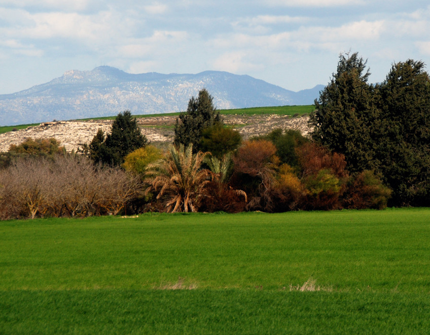
I turned off the Larnaca road and headed east towards Avdellero and Troulloi through the rolling and much drier marl hills. I was hoping to run into the potato growing area of the island (that exports very early new potatoes to the UK in January/February) but I saw mainly dairy farms.
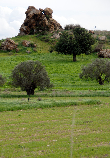
Avdellero passed quickly: there were some squat old stone buildings that were very attractive. Then I was driving into Troulloi past a great fist of rock on the skyline. It boasts two churches - one quaint and old, the other garish and new. I stopped briefly to stretch my legs and walk around the older church. Under the porch a couple with a young child seemed halted in some kind of despairing domestic dispute. I moved quickly by.
Out of the wind the sun was warm.
I continued on my way but was forced back down to the Larnaca-Agia Napa motorway by the Green Line. I headed back north-east when I could and travelled a strange stretch of road that goes along the TRNC 'border' and forms part of the territory of the British Sovereign Base Area of Dhekelia.
There were signs warning me that I was in close proximity to the Turkish Area and when I slowed at a roundabout, thinking to pull over and take a photo of an amazing show of wild anemones growing in some scrubland, I suddenly spied two 'Turkish' soldiers emerging out of the bushes. I was genuinely shock to see the 'enemy' so close. Naturally I desisted from my photographic compulsion and sped away as fast as my Suzuki Splash could take me. Which was surprisingly fast.

As I roared (as in the way a big lawn-mower might roar) I noticed the large abandoned settlement beyond the Turkish Cypriot 'border' line. I turned into a side-road to a reservoir and fishing club and from the shelter of the brow of a hill I took a few photos of the deserted village that seemed large enough to be a town.
I later learnt this was the former village of Achna or 'Athna' - the latter meaning 'small pieces of straw'.
The excellent PRIO website relates what happened there.
All of the village’s inhabitants were displaced in 1974, when they fled in August of that year from the advancing Turkish army and took refuge in the Dhekelia British Sovereign Base Area. Because they were within British sovereign territory, they were able to erect a provisional tent village only a hundred or so meters from their old village ... Later they began to build a new village quite near the village from which they had fled, this one within the Dhekelia Sovereign Base Area. The number of Greek Cypriots who were displaced in 1974 was approximately 1,980.
The Turkish Cypriots changed Achna's name to Düzce, literally meaning “slightly flat.” It is apparently used as a Turkish Cypriot military camp but from my fairly cursory look it seemed decaying and abandoned.

I didn't go the the vilage of Pyla, which lies in the Buffer Zone and is the only one on the island to still have a mixed community of Greek and Turkish Cypriots. This delicate balance and last vestige of a happier, if not always trouble-free, state of inter-communal relations could now be threatened by the plans of one of the University of Central Lancashire in the UK to build a campus there. UCLAN's own website coyly refers to the campus as being in 'Larnaka (Pyla area)'.
After UCLAN built the campus it earned, said the Times Higher Education Supplement (31 Jan 2013),
the spectacular distinction of being rebuked by the UN secretary general in a report to the Security Council.
The campus, 51% owned by UCLAN in a joint venture with a group connected with a Cypriot developer, Hassapis Group, currently hosts 140 students thought to be predominantly Greek Cypriots and there is a fear that this could provoke anxiety among the minority Turkish Cypriot community, particularly if numbers grow "towards 5,000" within five years, as UCLAN plans. The PRIO website gives the population of Pyla as 462 Turkish Cypriot and 1,379 Greek Cypriots in the 2000s.
The building of the campus in the buffer zone has apparently not been authorised by the UN, which has control of construction in the zone, although a UCLAN spokesperson insists that the campus, "is fully licensed by all the relevant Cypriot authorities".
The Pyla Community Council, has issued support for the project and stated that,"there are no minefields adjacent to or around the university area." (See above on this page on the estimated 15,000 mines still unaccounted for in Cyprus.)
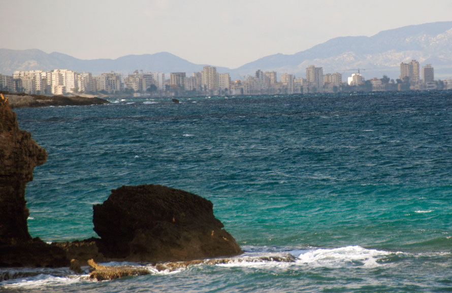
I headed east again and drove through Avgorou, where the Pierides Foundation Ethnographic Museum was closed, and on through Frenaros and Dherinia and down towards the east coast just south of Famagusta. Eventually I was brought to a stop by the Green Line, a Greek Cypriot watch-tower and a bizarre little zoo that also boasted a viewing platform to look over the line at the abandoned tourist hotels of the Famagusta suburb, Varosha.
The soil in the fields became a deep oxide-red and I was in the Kokkinokhoria or 'Red Villages'. I did see one field of potatoes but nothing like the wall-to-wall landscape of potato tops that I had expected (see here for Red Soil Potatoes based in Avgorou).
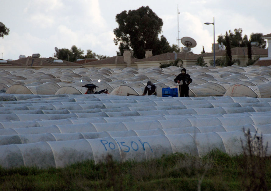
It was a funny place to end up. Down a muddy, sandy track with wave upon wave of villa development marching south along the coast towards Cape Greko and this weird little zoo hidden behind tamarisk bushes and a Greek Cypriot soldier watching it all from his tower. I umh-ed and ah-ed about whether to go in eventually deciding that I'd find my way down to the shore somewhere, through the great banks of 3-4m high reeds and the intensively cultivated fields covered with plastic tunnels. Which I eventually, after a false start or two, did.
End of the line: polytunnels, villas, more villas and the tiny cove of Agias Trias


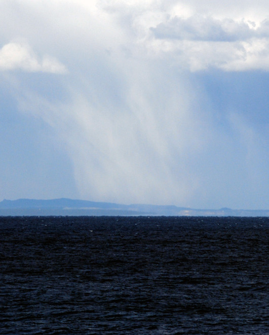
I stopped in the car park above Agias Trias which I found after driving around dead-end villa streets that terminated in water-cut gullies of wash and rubbish where the tarmac, and development, ran out. I chewed away on some lefttover Christmas paneforte I'd brought from England as the wind rocked the car. Everything seemed shut up tighter than Chancellor Osborne's wallet. Far away to the north-east I could see the Karpas Peninsula stretching away under driven clouds that massed into a huge storm over where I imagined Syria lay less than 100km away. (I later learned the country and the refugee camps on its borders in Jordan and Turkey had experienced its worst winter storms for 20 years.)

I pulled on all the clothes I had: jacket and cagoule, gloves, hat, scarf, and stumbled, leg-cramped and ass-sore, out the car and into the wind. I walked along the path that wandered along the top of the stubbly, bubbly foot-cutting cliffs and little bays. The light was brilliant, the colours staggering, if you ignored the villas edging down to scrubby littoral of vegetation spared between the hammer of development and the anvil of sea (thanks to John Berger).
There was not a soul on the beach - you would have been mad to - as the waves slapped in and the gale buffetted the turquoise waters. I could only imagine the crush that the summer would bring as the villa-packed streets - that went bank rank-on-rank - emptied out after the hottest part of the day. Signs advertised boat trips to Famagusta for shopping and the beach to escape the crush.
I got myself out on the furthest promontory where I could see the towers of abandoned Varosha flitting in and out of the sunlight. I steadied myself in the gale, twisted the lens out to maximum magnifcation and took some photos, my eyes streaming tears in the blast.