
The Lyngen Alps in Arctic Norway
Introduction
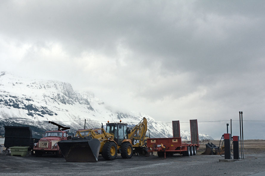
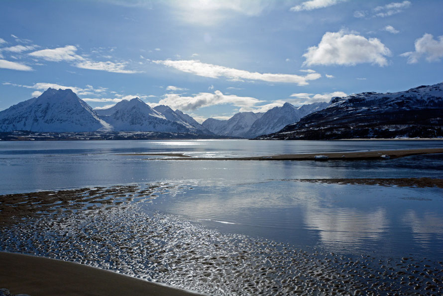
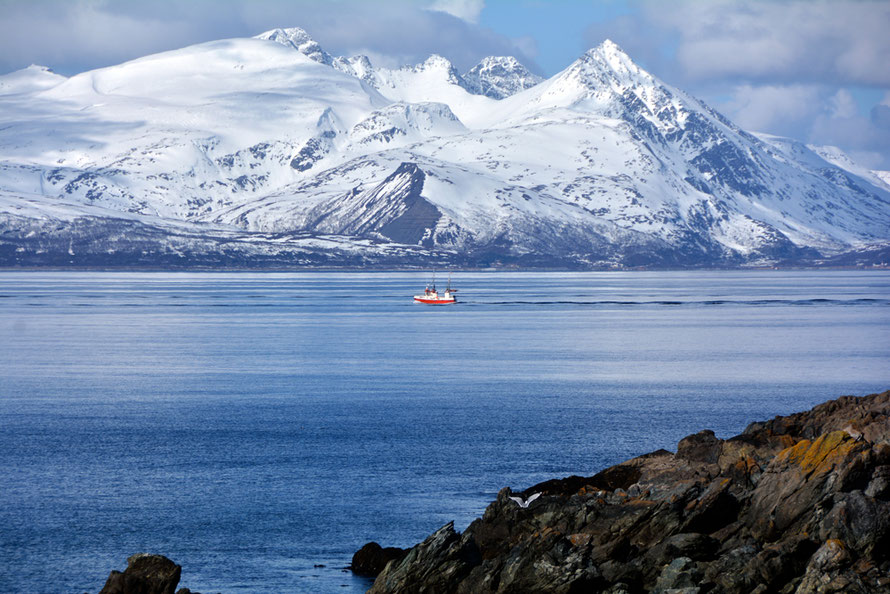
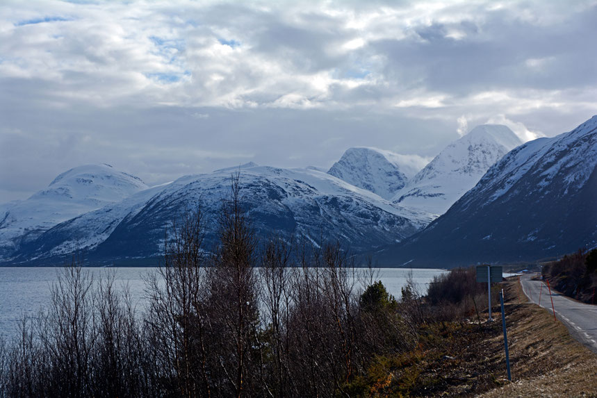
Our long day driving around the Lyngen Alps - with a walk at the far end of the Lyngen Penisnula and sightings of otter, dolphins and sea eagles whilst sitting in the blazing sunshine - ranks as one of the truly memorable days of my life. After the rather desolating experience of Senja Island and the interminable driving that day (the summer ferry was not yet working) in rain, fog and clinging low cloud it could not have been more different.
By the end of the day my eyes hurt from the low sun and The Principal had been driven to distraction by my constant photo stops accompanied by the 'I've got to, love. We may never pass this way again, and the light, oh, the light...'. Even a slip through a thin crust of snow into bitterly cold meltwater did not dampen my spirits. Although I did feel a bit of an idiot and was very surprised.

This page, started in May 2015, began as a showcase for that day and the photos I had taken. But, on revisiting it a year latrer, I found it a somewhat jumbled treatise on the formation of the stupendous Lyngen Alps. When the material on the formation ran out I ran down the familiar old road of Ice Ages and glaciation. And somewhere along the line I also ran out of steam or other priorities in my life became pressing. It was probably something to do with the arrival of spring and the demands of the garden. It usually is.
So it was quite strange to return to this page towards the end of May 2016 (there was a spell of unseasonally cold weather). Just as my steam was running out in 2015 and the garden was taking more of my time I had purchased the wonderful study of Norway's geological and morphological formation that is called 'The Making of the Land: The Geology of Norway'.
I bought my copy of this beautifully illustrated book from the UK Geological Society bookshop and for some reason (I think it was slightly damaged) it was being sold at a discounted price. It is available on Amazon at £59 at the moment. Having taken as much as I could from it online I hardly opened the book once it had arrived and it has sat on my shelves gathering dust.
On returning to the page I have tidied it up a bit and I will add some more of my photos. I really wanted to write more about the glaciation of the Lyngen Alps. I will read through 'The Making of the Land' and see if there is anything more of interest to add.
It was also on this day that as we returned down the side of the Lyngen Fjord, past the site of the 1810 tsunmai that was created when a massive rock slab fell into the fjord - something I first heard about when researching my pages on Milford Sound in New Zealand (see here) - that I stopped the car and took some photos of a settlement or campsite on the far shore of the fjord. And it was through making enquiries about this on our return to the UK that I stumbled across the dreadful history of the Lyngen Line during the Second World War when Norway was under Nazi occupation. This section of the website follows this page.

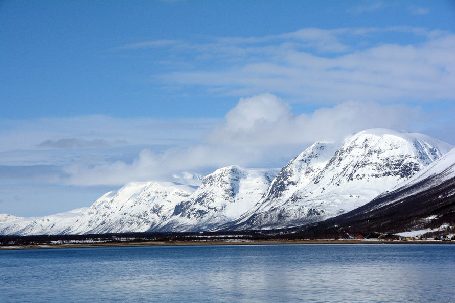
I suppose, looking back on what I had written earlier, that one of the things that intrigued me was what it was that gave the Lyngen Alps their 'Lyngen-ness'. The clue lies, of course, in the word 'Alps'. This descriptor sets them apart from many of the mountains in the Tromso district. The Lyngen Alps are 'alpine' but what does that mean?
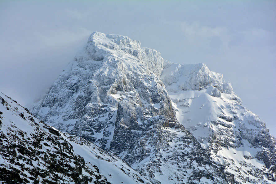
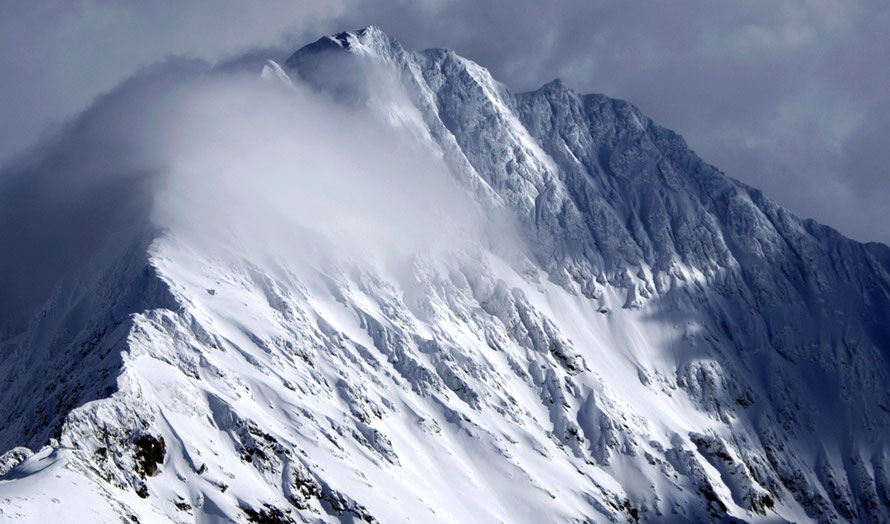
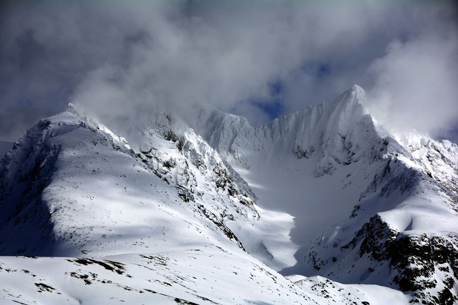
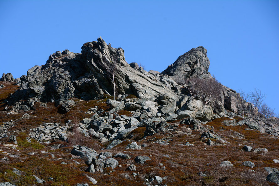
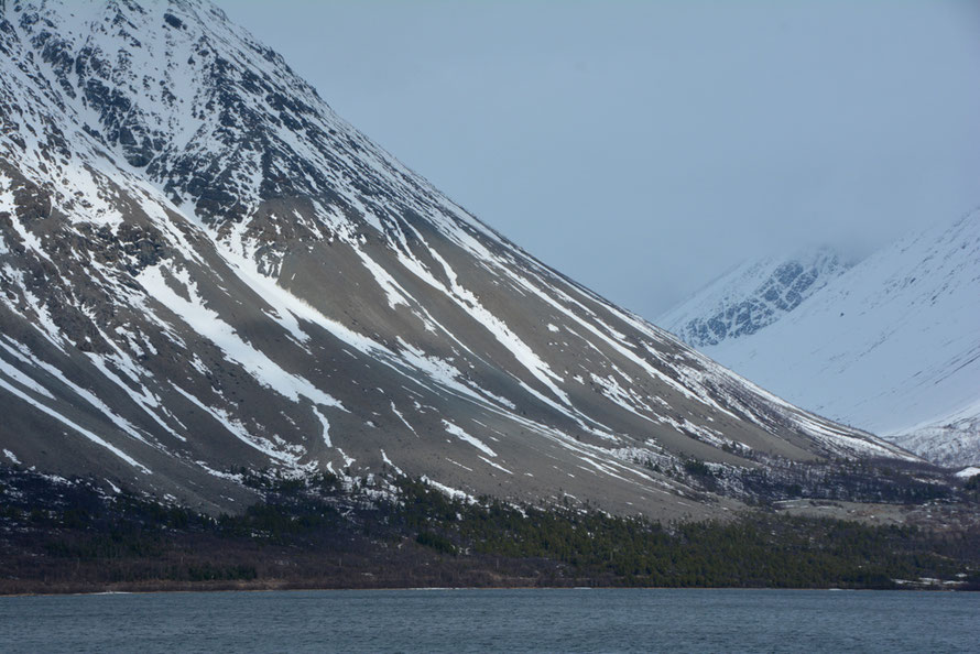
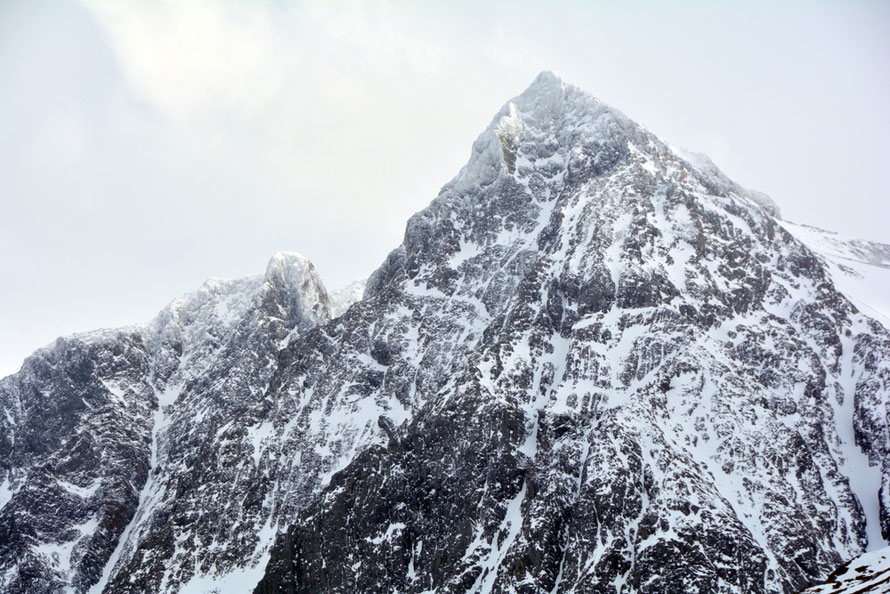
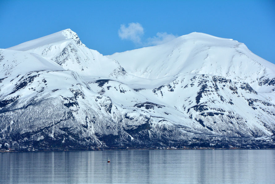
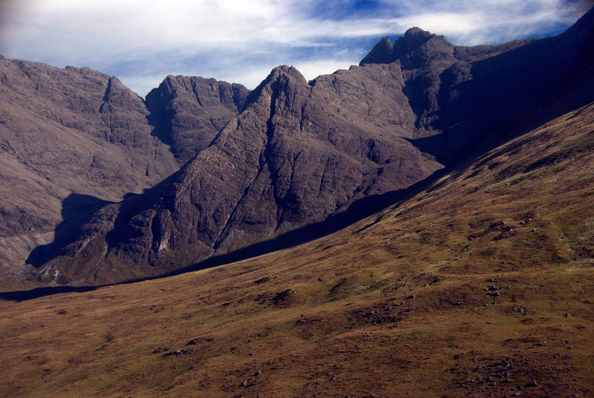
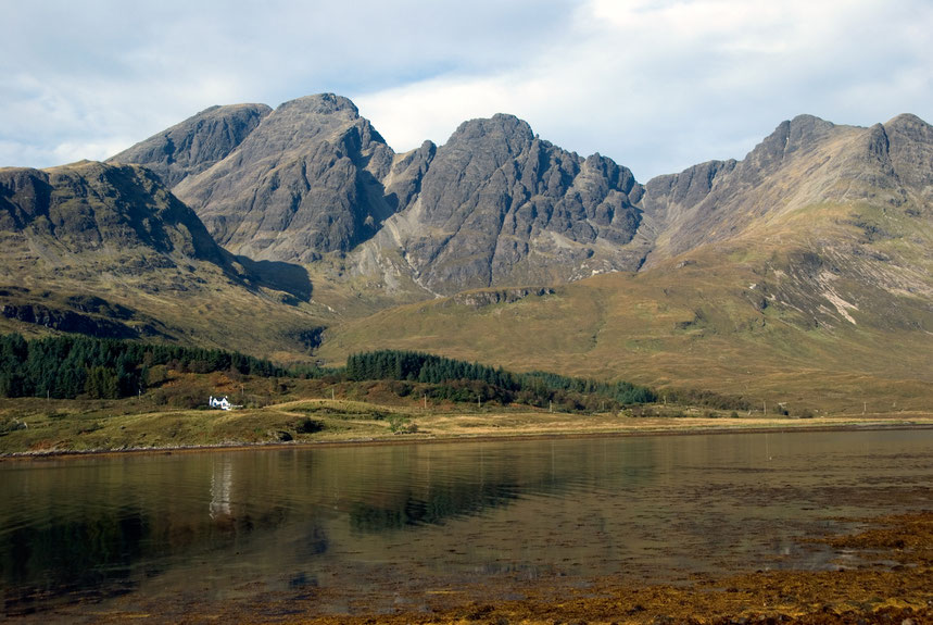
I suppose it means that they are spectacular and mountainous in a very specific way. They are almost like an 18th century Grand Tour-ist's fantasy of the Sublime - that mixture of grandeur and terror. They rise out of the sea precipitously, their peaks are the very epitome of peakiness - not some rounded meringue-like softness - but pinnacles and saw-tooth edges with near vertical walls of snow and rock. There are horns and arêtes that terrify even from the ground; the snow in great windswept banks, glistening with a strange, crisp creaminess in the absolutely clear air.
But if the Alpishness is important so is the Lygenishness. Because the Lynhegen Alps don't sit in the middle of Europe but at its Northern extremity and over 300 kilometres inside the Arctic Circle. That positional differential is important for the long dark winters and the intense cold at the summit altitudes of the Lyngen Alps.
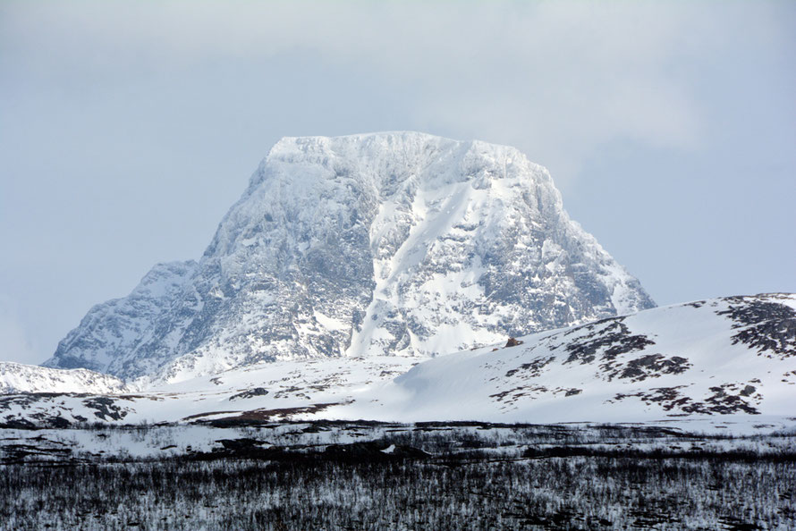
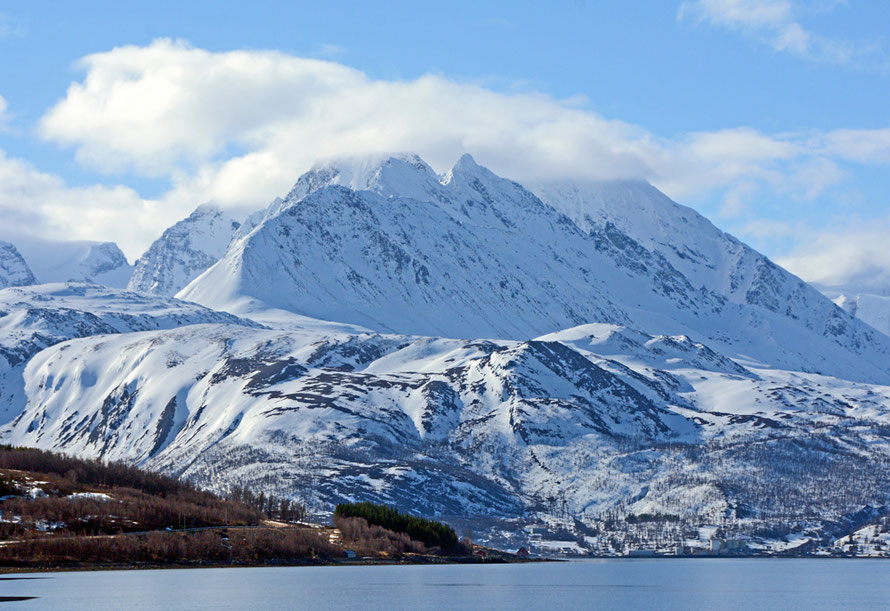
The Lyngen Alps are not actually that tall. They peak in the permanent snow and ice cover of Jiehkkevárri's summit at 1,834m. This is nothing compared to the Alps where Mont Blanc reaches 4,808m and there are 537 mountains that exceed 3,000m.
Perhaps what makes them special is both their latitude north and the climate that comes with that and the fact that they rise so precipitously from sea level: the summit of Jiehkkevárri is 6-7km from the shore of the salt-water Ullsfjorden. The land to the first western peak of the Jiehkkevárrii massif at 1666m rises 1,166 metres in about 1.3km at a gradient of 1:1.3 or 77%.
The major 44 glaciers in the Swiss Alps have a front height (where the glaciers stops) of 2154 metres. This is where the rate of snow accumulation and ablation or melting are equalised. This is due to a number of factors - rates of precipitation and ambient temperature being two of the most important.
In the Lyngen Alps five of largest glaciers (Fornesbreen, Gamvikblaisen, Stendalbreen, Strupbreen and Sydbreen have an average front height of 492 metres. That is 1,662m lower than the Swiss Alp glacier average front altitudes.
This low front height achieved by the Lyngen glaciers is admittedly beaten by the New Zealand's Southern Alp's Fox Glacier which comes to rest at 300m in temperate rain forest but this is largely due to the phenomenal rates of snow accumulation powered by over 10 metres of rain a year.
The Lyngen Alps are then very visible and if you can get to them the action is happening in front of your eyes.

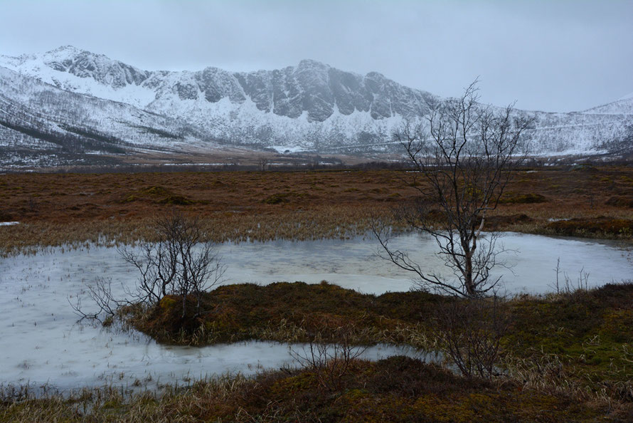
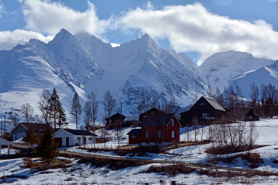
The sparse habitations are small and vulnerable, perched on raised beaches, only just breaking out of the snow in April. The silence and stillness of both days that I visited were deafening, the thingness of the mountains absolute. And up there in those snow-encrusted valleys I knew there lurked glaciers, avalanches, snow, freezing meltwater and any number of hidden hazards
And because the mountains march out across a peninsula it is easy to stand back and see them for what they are. There is a rawness and absence that is absolutely gripping, the spaces around the mountains, that which is gone, and has been carted off and dumped on the continental shelf in such vast quantities as to be unimaginable, leaving this landscape that looks like it has just come out of some very complicated mould, so absolutely crisp and clean, sheer and poetic. And yet, and yet, when you've taken all the photos you can and have tried to drink it all in and hold it in all its clarity and silence somewhere the real Lyngeness of it slips away and one is left with a slightly disappointing approximation.
No wonder the Romantic painters and poets bigged it all up down in the Swiss and Italian Alps using exaggeration and close framing and feigned contrasts to try and convey the drama of it, the 'feltness' of it all.
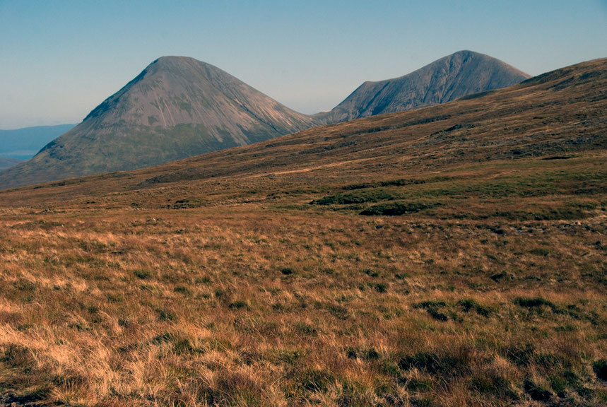
Because although Northern Norway is spectacular away from the Lyngen Alps and the Northern Lights route from Tromso down to the main north-south road has a fantastic sweeping, mountainy feel with its great expanses of water and mountains as outposts in the rolling plateau-like wilderness of birch forest and the occasional field and tiny settlements it seems to lose its concentration, the mountains get a bit lumpy, like irregular verbs, they lose that symphonic Wagnerian predictable flow that the Lyngen Alps seem to sing.
And while you are on the big roads there is some traffic and there is a sense of going somewhere and being visible and remembered. But when you head up the long road that grinds its way along the northern shore of the Sorfjorden to the dead end at Jøvik it feels like you are entering a realm of such enchanted desolation with the wind howling in the freezing air that you break into song at every battered house you see hidden behind its inadequate windbreak of birch and pine. Your mind is drawn to the long, long Arctic winter and the huge weight of darkness that leaves a whiff of damp and decay even in the scintillating light of the everlasting sun. It is as if there is no memory of your passing or your future, the web of community stretched so thin you wonder how it can hold when the brief summer ends and winter returns.

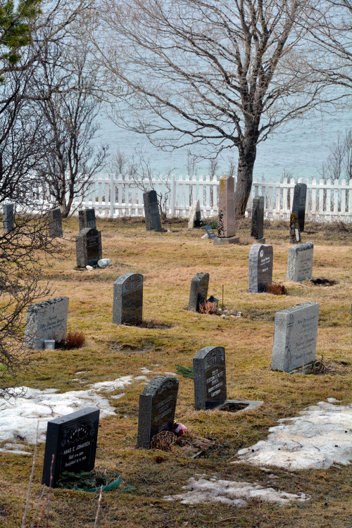
But I could imagine living there, something inside me thirsted for it, that sparseness, that up against-it-ness and in-ness of that towering landscape, the challenge it threw down, and the promise of some kind of redemption that it held with its old stone-walled cemeteries, its wood stripped back to ashen grey, its lichens and lingonberry wastes, the terrifying bare scraped mountain sides, the vast spills of till and scree, huge boulders perched, whole mountainsides defying gravity, waiting to crash and fall and wreak havoc.
The one shop I passed on the 45 kilometres of road from Laksvatn to Jøvik was where I bought a few things and poured myself a cup of strong coffee from the flask by the door. Everywhere there were boats and boat houses and fish sheds and long vistas to other isolated settlements camped on the parcels of flat land under towering mountains and the piled up masses of snow. A long funeral procession walked slowly under heavy skies to an isolated church, the wind blowing and blowing.

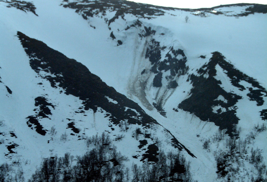
And later I wanted to understand just how that landscape had been made. Why it felt and looked so different. Everywhere there were signs of its making, such thick snow cover still in April, the scars on the valley sides, the great dumps of gravels and sands, boulder and moraine, the torrents and rivers, the torn jagged rocks, the exquisite peaks, the sheer, staggering verticality of it all and somewhere those hidden glaciers, buried beneath the snow.
My explorations and brief researches into the mechanics, the processes, weights and temperatures, rainfall and rocks of glaciation in the South Island of New Zealand at both the Fox Glacier and Milford Sound had alerted me to the great variation of glaciation and its longue durée .
It wasn't a flash in the pan as the brilliant The Ice Age: A Very Short Introduction by James Woodward had made very clear to me as I read and reread it. This was the work of a million years and more. A length of time almost unimaginable when our memories struggle to reach back five thousand years, a mere 0.5 per cent of a million.
I'd not really thought about glaciation as a process over centuries and centuries that had periods of advance and retreat, warming and cooling, and the shift from ice caps thousands of metres thick and dry-bed glaciers frozen to the valley floor and held in place by the surrounding pinioning ice fields to the stages of the moving wet-bed glaciers free of their shackles grinding out another layer of rock, advancing up the valley through backwall plucking and creating deeper valleys to coral and accommodate bigger and better glaciers.
I hadn't thought about the number of times a glacier would grow and melt, and maybe disappear altogether; the successive passes over bedrock like a carpenter's plane, this time smaller, this time bigger, relentless and without pity, grinding the rock to dust to be carried away as glacial milk by the meltwater streams coursing blue and menacing beneath crevasses and ice fields.
I hadn't thought about the way in which the character of the bedrock, its hardness, its angle of incline, its faulting and bedding plains, the pre-glacial topography, it's general slopeiness, the fall of gravity, and ambient temperatures and rates of accumulation and ablation (melting) all had such a role to play in creating a particular characteristic landscape that actually varies incredibly.
Why are the Lyngen Alps so Alpy and why the Black Cuillins of Skye so Cuillinish, particularly when there are other adjacent mountains in Northern Norway and the Red Cuillins on Skye even that display a very different Cuillinishness to the Black Cuillins? Does it just come down to the bedrock type - gabbro in the former and the exotic nappes of various sedimentary and metamorphic rocks and granite in the latter? Maybe it wasn't just the difference in the hardness, thrust, bedding and faulting of the bedrock at the time of glaciation. Because remember there was a huge period, longer than anyone could imagine between the placement of the gabbro and other nappes in Troms country and the arrival of the ice ages. Hundreds of millions of years. And in that eternity differential hardness and faulting and uplift all played their parts in differential rates of erosion and the development of topographic forms.
Was it that the hard gabbros resisted better and maintained their lofty heights and that the valleys carved out by the higher rainfall into the harder rock were more intense and steep and enclosing so that when the ice began to form it had a tight course and superior temperatures to work with? And when it left that hardness continued to play its part by resisting the slow drip drip of erosion. It could only be broken by freeze and thaw. It wouldn't bend and round itself to the yoke of rain and wind but only understood the mastery of snow and ice and the grinding immensity of the glacial engine building up a head of stream in its heights?
These were the questions and thoughts and feelings I really wanted to get at on this web page. To get some sort of sweeping, rollicking sense of all this and to convey and capture my sense of awe at it all. But the language and practice of geology is so complicated and detailed, so specialised and hedged about by techniques and obscure linkages that to read it and try to summarise it is to have the energy sucked out of it.
And the guffaws of unseen experts throw out their own intimidating force-field that fills me with a tremulous unease that buries the visceral experience, so naive in its lived empiricism, from recall and view. And it is as if the specialisation and academicisation of knowledge stops people saying simple and striking things. Or asking questions the answers of which an academic journal could not publish for fear of ridicule and simplicity.

What follows is an attempt to understand through the geology sources I could find what it is that accounts for the Lyngenishness of the Lyngen Alps and what gigantic forces made them. Maybe one day I will be able to come back and learn more about them by being in them. But until then this will have to suffice.
The Geology of the Lyngen Alps
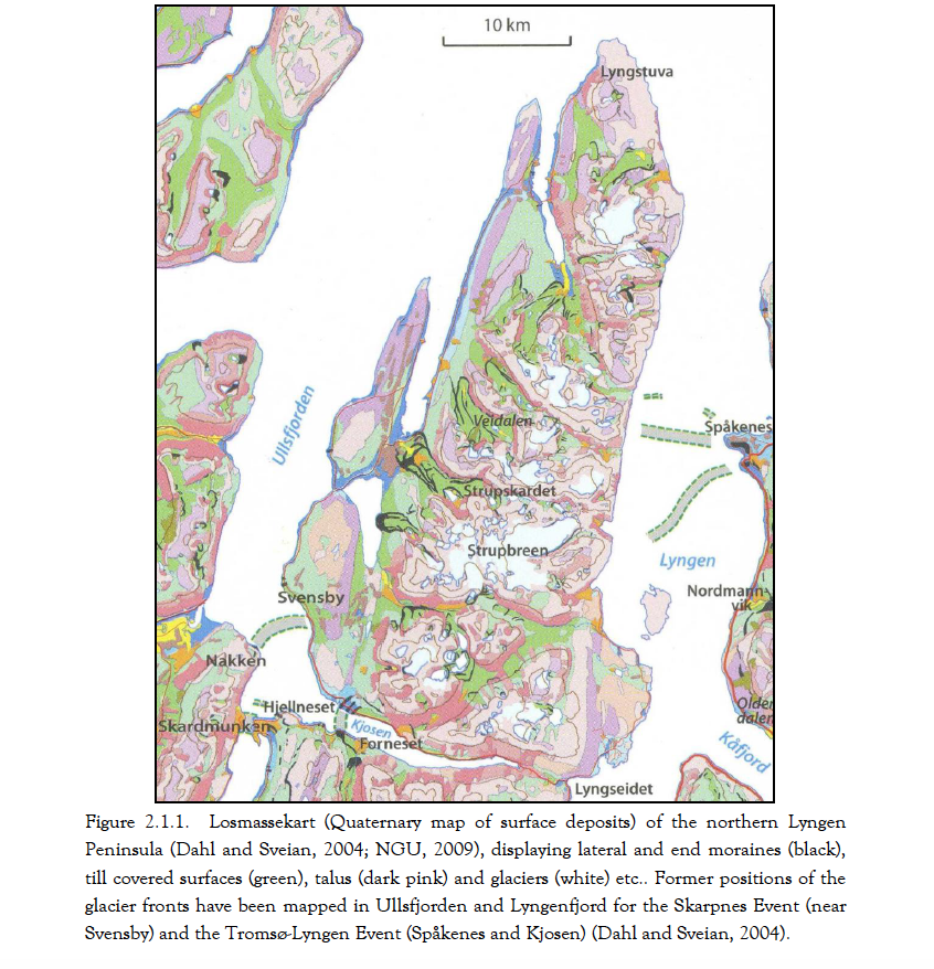
The Lyngen Alps (Lyngsalpene) are a chain of mountains 20 km wide that runs north-south along the 90 km length of the Lyngen peninsula (Lyngenhalvøya). This is surrounded on its western by Ullsfjord and Sørfjorden and on its eastern side by Lyngenfjord. It is almost bisected into a northern and a southern part by the deep inlet of Kjosen. The total area of northern Lyngen Peninsula is 614 square kilometres, of which glaciers presently cover 47.26 square kilometres (7.7% of the land area).
Perhaps we should start at a beginning: the formation of the Lyngen Gabbro 469 million years ago.
The geology of northernmost Scandinavia is dominated by two bedrock units - the Precambrain basement and the Caledonian Mountain Range.
This geology has only relatively recently come to light. As is often the case it has in part been driven by economic considerations - first the Kiruna iron ore reserves - formed in the Precambrian - and more recently the discovery of hyrdocarbon resources.
The Precambrain basement (rocks formed before the Cambrian Period - 500-600 MYA) is aged between 2,500 and 1,500 MYA. The Basement was largely formed in the Svecokarelian Orogeny (1,950-1,750MYA). In this granodiorites and gneisses dominate. It's easy to say all this. But that is old, older than old, and some rocks are as old as 2,900MYA in the period known as the Archaen. This is more or less the same age as the Lewisian gneiss that makes up the bedrock and surface rock of Lewis in the Outer Hebrides.
But to move on. The Caledonian Mountain Range (550-350MYA) that ran from Arctic Norway through Britain and Ireland and parts of Greenland was formed by the coming together of the ancient continents of Laurentia and Baltica over at least 100 million years.
As an aside, this is surely part of the problem of geology. It is dealing in such vast lengths of time and our experience of time is so short, that it is incredibly difficult to both summarise 'a mountain building phase' in a few pages of a book and give a sense of the almost infinitesimal length of time it took to achieve the building of those mountains.
As part of this process,
"vast horizontal slices termed nappes or allochthons in modern terminology, [were] pushed by unknown forces over distances of hundreds of kilometres from unknown source areas in the northwest to their present position on top of non-transported, 'rooted' basement (or autochthon)" (Lindstrom, M. 1987, Northernmost Scandinavia in the geological perspective, Ecological Bulletin 38, p.18).
This process is sometimes known as orogenic wedging - in effect the basement rocks and accretions onto and intrusions into these are scraped off and pushed backwards into a rising wedge of mountains with accompanying deformation, buckling, faulting and thrusting created by the massive pressure and heat of tectonic plate collision over millions of years.
So the pre-Cambrian basement was formed 2.9 to 1.5 billion years ago. Then it sits there being eroded for another billion years when along comes the Cambrian Mountain orogeny. By this time the basement rocks have been worn down to a relatively flat peneplain. From somewhere and somehow huge, massive, colossal amounts of rock kilometres thick are scraped and stacked and moved (up to 300km) and buckled and welded on top of the ancient bedrock. These great wedges of rock are known, in geological circles, as nappes.
A 'nappe' in French is a tablecloth and the idea is that the rock thrust over the bedrock crumples up like a table cloth pushed over a smooth table top. The 'thrust sheet' thus mobilised can give rise to other exotica -imbricate thrust stacks, fensters and the klippe. A klippe is an outlier of the nappe, a fenster is a gap or window within it and the imbricate thrust stack - well, you'd think it was a stack thrown up by the massive forces involved in the thrust plain.
This seems another problem with geology - we are looking for analogies that often seem totally inadequate: to compare a French tablecloth to the forces that made the Swiss Alps or Himalayas seems just a tad inadequate. Even a 'thrust-sheet' is too insubstantial and too quick - 'Quick, darling, throw the thrust-sheet over the table, the guests are here' might work in a suburban house but to describe mountain building? It's a bit on the flimsy side, isn't it?

These nappes vary in thickness from several hundred metres to a 'few kilometres' (Lindstrom) and can occupy from tens to thousands of square kilometres.The Lyngen Peninsula (694 square kilometres) is dominated by a
'100km long slab that consists of a suite of gabbros, sheeted diabase dykes and other basic magmatic rocks. These rocks evidently belonged to the crust underlying a part of the Iapetus Ocean during the Finnmarkian [540-490MYA] orogeny ... and were overthrust ('obducted') on bedrock deformed during earlier Finnmarkian tectonism ... The Lyngen Gabbro was elevated above sea level and forcefully eroded. (Lingstrom 1987, p. 28)
The Lyngen Magmatic Complex itself sits on top of another nappe - the Reisa Nappe Complex. 1995 research has mapped three of the Lyngen units and shows a more complex differentiation of rocks
than a single massive area of gabbro (see Oliver, G.J.H. and Krogh, T.E., (1995) U-Pb zircon age of 469 + 5 Ma for a metatonalite
from the Kjosen Unit of the Lyngen Magmatic Complex, northern Norway in Nor. geo. unders. Bull. 428, 27-32.
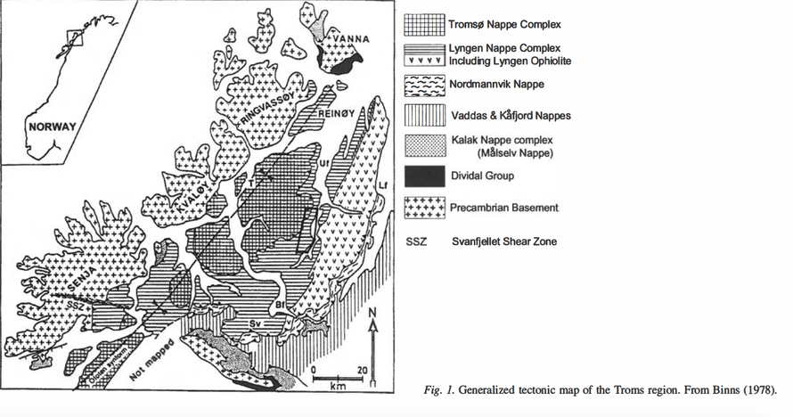
The chart below from Coker-Dewey et al. (see Coker-Dewey, J., Steltenpohl, M. G. & Andresen, A., Geology of western Ullsfjord, North Norway, with emphasis on the development of an inverted metamorphic gradient at the top of the Lyngen Nappe Complex. Norsk Geologisk Tidsskrift, Vol. 80, 2000) shows the position of some of these nappes and the Precambrain Basement in the area around Tromsø and the Lyngen Peninsula.
The Precambrian Basement dominates the large islands to the west of Tromsø - Senja, Kvaløy, Ringvassøy and Vanna whilst the Tromsø and Lyngen nappes dominate the area to the east of Tromsø.
The Lyngen Nappe consists of both the Gabbro from which the Lyngen Alps were formed and the Balsfjord Group. This and the other nappes of the Tromso area were 'regionally metamorphosed and show evidence of multiple deformation' (Coker-Dewey et al 2000 .p.111).
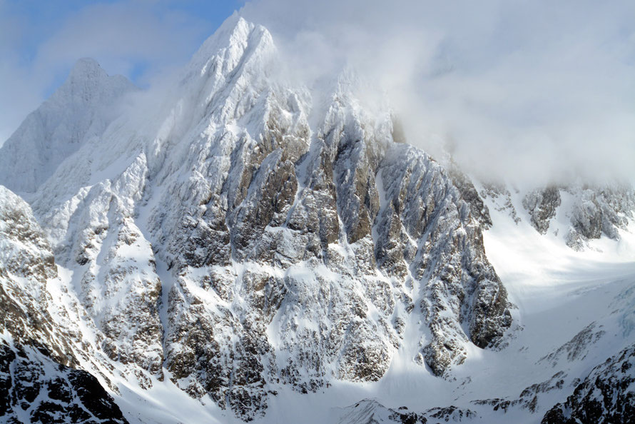
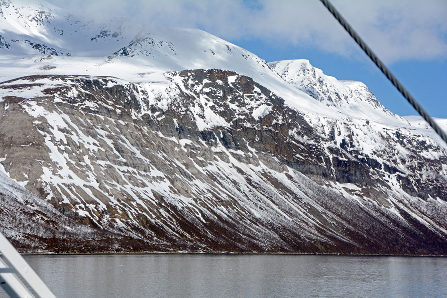
The Lyngen Alps are largely formed of gabbro. The name, Gabbro comes from a town in Tuscany in Italy and, 'refers to a large group of dark-green/dark, dense, hard, coarse-grained, mafic [magensium+iron/ferric = mafic] intrusive igneous rocks chemically equivalent to plutonic basalt.'
Gabbro 'forms when molten magma is trapped beneath the Earth's surface and slowly cools into a holocrystalline mass.' Gabbro can form one massive intrusion or be accumulated from different layers of intrusive activity. It can also cool into distinct layers as minerals in the molten rock group group together.
When polished and used as dimension stone it is often called Black Granite.
Gabbro is classed as a 'hard' rock as opposed to 'very hard'. It is as hard as some granites, but not all, and not quite as hard on the upper scale as gneiss (a metamorphosed granite and diorite - see matweb.com).
The Lyngen Alps in Sub-Arctic Norway and the Black Cuillin's on Skye are classic Gabbro landscapes. Fiordland in New Zealand is a glaciated gneiss landscape (see my Fiordland page here).
But many other factors effect the 'erodibility' of rock types - cleavage plains, faulting, permiability, etc. One site told me that Gabbro 'is 7 on Moh’s hardness scale'. Talc is 1 on the scale and diamond 10. The Moh hardness scale is a scale of the scratchibility of one rock by another and is useful for identifying minerals in the field. Gabbro is pretty scratch hardy. But Gabbro is not only scratch resistant but it is also tough, course grained and presumably does not split easily. Gabbro also seems to differ from granite in that it is less easily quarried as sheets - bedding joints - although it can be broken by many vertical joints. Gabbro is currently used for much road bed and construction aggregate.
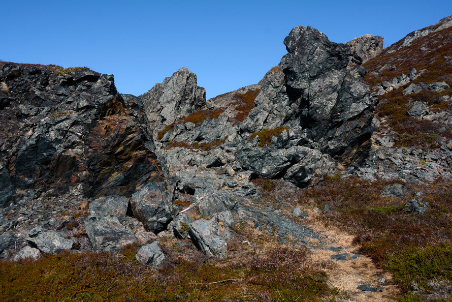
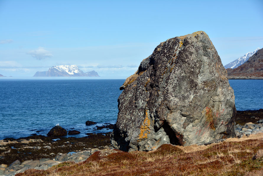
The Lyngen gabbro nappe may have been more fractured than in situ gabbros due to the violent process of thrusting that raised it up onto the pre-Cambrian bedrock and then transported it over 150km under conditions of great heat and stress. My photographs of the snow and ice-covered Lyngen peaks appear to show an angle of thrust of between 60 to 80 degrees from the horizontal with strong layering.
In the photo below of Litle Lenangstinden in the Lyngen Alps the gabbro the mountain is made of looks pretty tough. But then again an awful lot of it has been eroded.
The mountains of Lyngen comprise the largest fragment of early volcanism in Norway, where stretched and flattened pillow lava can still be seen. The Lyngen Peninsula is dominated by a gabbro and metagabbro lithology comprised of light-coloured plagioclase and dark pyroxene and amphibole.
from Greig, D., (2011) Moraine chronology and deglaciation of the northern Lyngen Peninsula, Troms, Norway g Masters Thesis in Geology, University of Tromsø.
There are some nice pictures of Gabbroic rocks from around the world here.
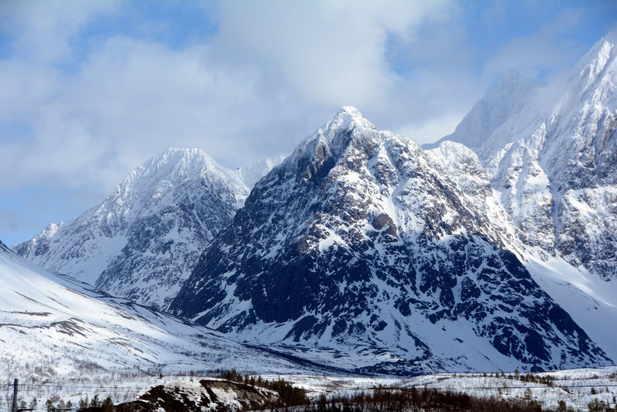
I stopped by the side of the road on my trip to Jøvik. Small pine trees stood in their own little drip-belt clearings in the snow. Behind them was a huge glacial erratic on which some interesting clubmosses were growing (see this page on sub-Arctic flora and fauna). The rock had been much shattered and there were strong vertical faults and bedding plains present. Note also the rust markings in the photo below and the characteristic olivine hue. This erratic may have been brought down from the nearby Jiehkkevárrii massif.
The gabbros of the Lyngen Peninsula are part of what is termed an 'ophiolite' which is a section of the sea floor crust that has been heaved up over the basement rocks. Another well known ophiolite forms the Troodos Mountains in Cyprus (see my pages here).
'Ophiolite derives from the Greek for serpent/snake - ophio - as it was found that seafloor crustal rocks often had a shiny surface - as in the aptly named 'serpentine'. Serpentine occurs on the Lizard Peninsula in west Cornwall and in places on the Lyngen Peninsula. The name 'Lizard' does not in all probability refer to the serpentine but rather is a corruption of the Cornish "Lys Ardh", meaning "high court".
A cross section of a complete ophiolite sequence would go something like this - from top to bottom:
- a thin layer of pelagic sediments
- pillow lavas
- a sheeted dyke complex of up to 1km thick
- several kilometres of massive gabbro
- layered gabbros
The above are the rocks of the seafloor crust. These are underlain by the mantle rocks of
- ultramafic cumulates
- Harzburgite (peridotie)
- Lherzolite (peridotite)
(see Making the Land, p.184).
The Shetland ophiolite on Unst displays an almost complete ophiolite sequence. Here the periodite layer is 2km thick, then a layer of dunite at 2km thick (with an intervening 500m of interbanding). There is then an irregular layer of pyroxene-rich banded wehrlite of 1km and then the gabbro layer that is three km thick. This is topped by dykes of fine-grained basic rocks and this in turn is capped by metavolcanic rocks. In all the Shetland ophiolite is over 8km thick. (See Strachan, R. A., et al., 2003, 'The Northern Highland and Grampian terranes,' in The Geology of Scotland, Trewin, N.H., ed., p.118)
So where did the gabbros in the Lyngen ophiolite come from?
The magma that formed the Lyngen Alps apparently derives from a back-arc basin type of sea floor spreading similar to mid-ocean ridges with the addition of 'slab-derived material and melting in the mantle's edge'. The minimum age of the Lyngen Magmatic Complex is 469 MYA (see Kvassnes, A., Strand, A. H., Moen-Eikeland, H., Pedersen, R. B., 2004 The Lyngen Gabbro: the lower crust of an Ordovician Incipient Arc, Contributions to Mineralogy and Petrology p.358).
Back-arc spreading occurs when the sea floor parts near an area of plate subduction - something that was not thought possible until relatively recently within tectonic theory - and magma is extruded through sea floor spreading.
(For a discussion of back-arc spreading see Pearce, J., and Stern, R., (2006) Back-Arc Spreading Systems: Geological, Biological, Chemical, and Physical Interactions Geophysical Monograph Series 166.)
Back-arc spreading appears to take place away from the zone of classic sea floor spreading and rather forms through island-arc volcanic activity betrween the sea floor spreading and the subducting plate. The gabbros are formed deep within the sea-floor crust, often as magma chambers.
During the Caledonian orogeny it is now thought that the Baltica plate was being subducted under the Laurentian plate when these met. The island arc with its gabbric intrusions and ophiolite sequence was squeezed between the plates and then raised onto the surface of the Baltica plate. This happened along the whole length of Norway's coast although the nappes vary hugely in terms of rock type.
The process of squeezing and raising the Lyngen nappe clearly took place over millions of years but it had the effect of deforming the nappes vertically under the strain of the plate meeting.
The thickening and bunching of the Earth's crust consequent to this deformation would have forced the basement rocks to sink into the mantle in order to create an isostatic equilibrium (imagine putting a load of gravel in a barge). Nevertheless, the authors of Making the Land are confident that the mountains thus formed would have equalled the Himalays in size, height and magnificence.
Once the Caledonides, which probably had similar or greater heights than today's Himalayas (Making the Land, ) had been formed little took place in Northern Norway geologically speaking for a long, long time - there are no Devonian to Triassic age rocks. Late Permian and Triassic sediments were formed of eroded material from the Caledonian mountains. On the island of Andoya Mesozoic sediments formed a bed 600m thick. But for most of Northern Scandinavia little happened other than the continued erosion of the Caledonian mountains until the Ice Ages of the Quaternary period (see Lindstrom 1987 pp. 20-34).
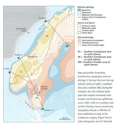
Except before this Norway experienced a period of uplift focussed in the south and north. 'In the Cenozoic the sub-Cambrian peneplain was uplifted by some 1000-1500 m' (The Making of the Land p. 457). Although the far north of Norway was little affected by this uplift there does appear to be a small area of extensive uplift that is close to the Lyngen Alps.
Previous to this uplift much of Norway was a lowland of undulating rocky hills that were the remnants of the Caledonian Mountains. This 'palaeic' landscape was then lifted up in two phases. One occurred in the early Cenozoic some 65-55MYA and was caused by an upwelling of magma under Iceland and then again the late Cenozoic when greater uplifting - up to 1000m - took place. (The Making of a Land, 2008, p. 488). This process is still not wholly understood. Uplift has continued through isostatic means both through the massive removal of material in the Ice Ages and also by the retreat of the ice. (See diagram below for differential uplift across Norway).
By the time the great erosional and uplift processes were supplanted by the last Ice Age presumably the gabbro layer of the Lyngen nappe/ophiolite had been exposed or thereabouts. This was then to be then to be glaciated on and off over the next million or so years by both wet and dry glaciers and ice sheets up to 3km thick to produce the forms that dominate today's Lyngen peninsula.

Norway's glaciation
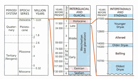
First things first. The world of the last Ice Age started 2.6m years ago - what is now seen as the boundary between the Neogene (formerly Tertiary) period and the Quaternary. The Quaternary is divided into the Pliocene (2.6m to 11,500 Before Present - BP) and the Holocene (the current interglacial period).
For the period from 2.6m years to 900,00BP 50 minor glaciations occurred. From 900,000BP something changed and the glaciations became longer and more severe. This was apparently determined by the 100,000 year cycles in the earth's orbital eccentricity - although the shorter climatic cycles of 43,000 and 21,000 years continued.
The last interglacial - the Eemian - lasted 15,000 years and was followed by the last glaciation - the Weichselian - which lasted about 103,500 years from 115,000 BP to 11,500 BP (the beginning of the Holocene). This is divided into three stages - the Early, Middle and Late. Within this enormous period (100,000 years) cyclical patterns created so-called interstadials - shorter periods of milder climate during glaciations - and stadials - longer cool periods when glaciers advanced.
In the later part of the Late Weichselian from 24,000BP three stadials have been identified - the Oldest Dryas (3,00 years), the Older Dryas (300 years) and the Younger Dryas (1,300 years). These were of markedly different lengths (see diagram below).
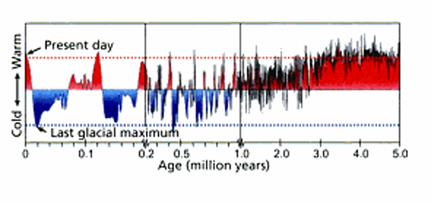
Three interlinked and overlapping phases are now thought to comprise the arc of Ice Ages from 2.6 MYA to the start of the Holocene 11,500 BP. These are:
- Interglacial periods with glaciers restricted to the mountains and a climate much like today's - these occurred throughout the period and occupied 1.2m years in total.
- Periods in which the Scandinavian Ice Sheet extended to the coast of Norway. This occurred throughout the period but was dominant between 2.6 and 0.7 MYA. This occupied 1.3m
years.
- Intervals in which the ice sheet extended across Sweden and Finland and pushed as far south as southern Germany. 'This period is restricted to relatively short intervals within individual
glacial periods and first occurred 0.9m years ago' and occupied 200,000 years. (The Making of a Land, 2008 p.487).
This is represented in the diagram below.
Dry and Wet Glaciers
Current ice caps and glaciers above an altitude of 1500m in Northern Norway are dry-based. Glaciers below this altitude are wet-based. Weathered bed rock and colluvium can occur under dry glaciers but there is generally, 'an absence of basal glacial erosional features [and] ... ice-marginal channels cut into [the] weathered mantle' (Gellatly et al. 1988, Thermal Regime and Geomorphology of Plateau Ice Caps in Northern Norway, Geology, p.983).
I hadn't realised this important difference in Ice Age morphology and landscape construction. A glacier can only form classic post-glacial landscapes if that glacier has somewhere to go and something to make it go there and a little bit of lubrication.
If a glacier is in effect blocked because it is part of a huge stationary ice sheet it will struggle to do much of the heroic eroding we think of glaciers achieving. But when a glacier exists as a stand-alone mass of chanelled ice and is propelled by gravity and lubricated by its own meltwater it suddenly becomes a monstrous bulldozer and wrecking ball.
The wet glaciers of New Zealand's Southern Alps are classic examples of this destructive power. Fuelled by 10m+ annual rain/snowfall they run from 1000s of metres of altitude to 300m above sea level over a course of miles (see my pages on the Fox Glacier for detail).
But when a glacier is locked-in by surrounding ice and there is no meltwater it cannot do much huffing and puffing. As Fredin et al. (2013) have recently concluded,
glaciers and ice sheets may rest on the ground for long periods of time without affecting the landscape. In fact, a nonerosive ice sheet may even protect delicate landforms from subaerial processes (p. 6).
So although there have been up to 40 glacial cycles in Scandinavia over the last million-plus years it is only in the last 700,000 years that 'full-scale glaciation cycles have been operating such that the dominant mode of glaciation is centred around the mountain chain, where also the main erosion has taken place' (p.6).
It is strange to say, but not all the mountains of Norway are glaciated. Or more precisely, some of the mountains of Norway, despite being under ice thousands of metres thick do not show any sign of classic glaciation - massive erosion by valley and cirque glaciers.
So glaciation affected Norway selectively. For example, pre-Quaternary river valley landforms are still found in the Norwegian mountains. How is this possible? These pre-glacial relicts were either preserved by remaining ice-free islands (nunutaks) close to the current Norwegian coast or by so-called 'frozen-bed preservation of the pre-glacial landscape beneath the ice sheet'. (p.8).
These pre-glacial relicts are often gently undulating blockfields (fellsenmeer - seas of rock). These differ from glacial landforms in that the rocks have been weathered and separated in situ by periglaciation (freeze-thawing in particular) rather than through the grinding and shattering of movement associated with wet-base glaciers.
Fredin, O., Bergstrøm, B., Eilertsen, R., Hansen, L., Longva1 O., Nesje, A., Sveian, H., (2013) Glacial landforms and Quaternary landscape development in Norway In Olsen, L., Fredin, O. and Olesen, O. (eds.) Quaternary Geology of Norway, 13, pp. 5–25
The glacial maxim - the Late Weichselian (20-18,000BP) - saw most of Norway, Sweden and Finland covered in a massive ice sheet that reached a thickness of 3km (p.16) and stretched from the Norwegian continental shelf over the Gulfs of Bothnia and Finland and well into Russia (Mangerund below p. 13).
After this point the ice sheet began to be melted back, only to stop and advance somewhat in the so-called Younger Dryas (12,800 and 11,500 years BP). This has been accurately mapped using end-morraine deposits. The ice sheet at this point covered all of Norway (but for some of the far north of Finmark and some of the SW coast) most of Sweden and all of Finland and had a maximum thickness over central parts of Norway of well over 1000m (Mangerud, J., 2011, Ice sheet limits in Norway and on the Norwegian continental shelf in Ehlers, J. and Gibbards, P., (Eds.), Quaternary Glaciations: Extent and Chronology 2011, pp.13-16).

The extent of the cold-based/frozen-bed glaciers and ice sheet was really very extensive in the most intense period of the last Ice Age - the Weichselian. This covered most of Finnmark and the mountain belt running down Norway's spine into the south west (see Making of a Land 2008 p. 492).
The evidence we see today of glaciation can really only relate to the last glacial period because due to its severity and duration it pretty much over-marked and eroded away the results of previous ice ages.
But the overall erosive power of glaciation is an accumulation of the impacts of the many smaller and large ice ages and their stadial and interstadial fluctuations.
It has been calculated that,
if the average Quaternary erosion of 610m [in depth of rock] in the Sognefjord drainage basin is representative, about 35,000 cubic kilometres of rock was eroded from the fjord region of western Norway during the Quaternary [ie in 2.57m years].
It has also been calculated that the erosive powers of the glaciers in the fjord region of West Norway eroded the bedrock at an average rate over the entire 2.57m year period of the Quarternay of 2 ± 0.5 milimetres a year. That may not sound very much but the rate of erosion of course varied by time and place - a wet glacier flowing from a high mountain cirque being the most erosive. And it is the accumulated erosion of hundreds of thousands of years that creates mind-boggling amounts of erosion.
see Nesje, A., Dahl, S.O., Valen, V. and Øvstedal, J. Quaternary erosion in the Sognefjord drainage basin, Western Norway, Department of Geography and Geology, University of Bergen.
To take an example using granite as the bedrock we can calculate the weight of rock eroded.
A cubic metre Granite has a specific gravity of 2.7 and a cubic metre weighs 2,700kg or 2.7tonnes.
There are 100 million cubic metres in a cubic kilometre. So a cubic kilometre of granite would weigh somewhere in the region (give or take) of 270 million tonnes.
Now multiply that cubic kilometre weight of 270m by the estimated 35,000 cubic kilometres of erosion during the ice ages in the fjord region of Western Norway. That gives a total of 9,450 billion tonnes (9,450,000,000,000) of rock removed over a 2.57m year period.
Where, you might ask, did all that rock go?
Well, it seems that much of it was deposited as huge trough mouth fans in the Norwegian Sea that start at the edge of the continental shelf. The Bjornoya Fan between Northern Norway and Svalbard is the largest and covers an area of 215,000 square kilometres - which is two-thirds the size of mainland Norway (The Making of a Land, p. 496).
Overall, although the New Zealand glaciers are much further from the South Pole than the Norwegian ones are from the North Pole the Fox and Franz Josef glaciers get close to sea level due the huge accumulations of snow that balance out a much faster rate of ablation with a stronger rate of accumulation and throughflow - partly due to the continuous wet-based nature of the glaciers - than the Northern Norwegian glaciers. These later above 1500m are dry-based and move relatively little as cirque glaciers.
Further south in Norway where precipitation is much greater the giant glaciers of the Jostedalsbreen are more like the dynamics of the Fox and Franz Josef glaciers, particularly when the moderating influence of the Gulf Stream is taken into account.
Glaciation only takes place in hard rock areas?
Doing the dishes the morning after the frustrating day before looking for details of the Lyngen Alps glaciation I thought to myself - why does glaciation only take place in hard rock areas. Which got me to thinking.
To address that question we need to think about Ice Ages and the swing back and forth between glacial maxima and minima.
When an Ice Age starts seasonal and annual temperatures gradually decrease. This has the most 'effect' in upland areas where rainfall and snowfall tends to be greatest and where the number of days below freezing grows. As this happens snowfall (as opposed to rain) increases and the accumulation of snow and ice speeds up. That is, the rate of accumulation begins to exceed that of ablation (melting) and glaciers begin to form.
This occurs first at high altitudes in cirques and cwms where snow collects - either through drifting, snowfall itself or avalanches from higher ridges. This first starts on the leeward side of the higher ground with regard to prevailing moisture laden winds and on those slopes where there is the least direct sunlight. Those cirque and cwm glaciers eventually overtop their lips and begin the formation of extensive plateau glaciers and then begin to flow downhill as valley glaciers, often following the course of water-eroded fluvial valleys. This is helped by falling lowland temperatures which curtail the rate of ablation at lower altitudes, particularly in the summer - much helped by the shift from rainfall to snowfall.
There is a balance to be struck here, so to speak, because if temperatures were to fall dramatically glaciers would become cold-based glaciers - their bottoms so cold that they freeze to the rock below them rather than sliding over it. If this happens glaciers hardly move - or the ice flow takes place within the core of the glacier rather than at the meeting place of the bedrock and ice. When this happens the erosive power of a glacier is pretty much nullified. It is the meltwater and the pressure temperature at the bottom of the glacier that gives it the ability to pluck huge chunks of rock from the bedrock and turn itself into both a massive digger and a super-powerful grinding machine.
The moving valley glaciers (and ice sheet edges?) were the great 'sweepers' and 'ploughs' of the Ice Ages that moved the huge piles of accumulating debris from cirque and plateau glaciers and swept it forward and to the sides as terminal and lateral moraines.
So in this picture glaciers first form in upland areas - which tend to be made of hard rock. This is because when mountain building takes place - by uplifting through tectonic dynamics or related volcanic activity - it is a slow process and softer rock is simply eroded away before it gets a chance to form a mountain. And if it does glaciation would rapidly erode it.
Furthermore, the very process of mountain building through tectonic collisions tends to turn softer sedimentary rocks – chalks, sandstone, mudstone, limestones – into harder rocks through the process of metamorphosis that occurs as rocks sink towards the mantle, are subducted, intruded upon by molten magma, and subjected to immense pressures and temperature as plate collides and nappes are formed and emplaced. See the example in the building of the New Zealand Southern Alps from metamorphosed greywacke formed from nothing more than muddy sediments (see my page here).
As the Ice Age develops the glaciers become larger and larger and flow further into their downstream hinterland - usually following previously water-formed valleys but also picking out fault lines and weaknesses in the bedrock over which they travel. The glaciers also become thicker as accumulation rates exceed ablation/melting and as new side glaciers in lower ground are formed and flow into the main glaciers as tributaries.
At the same time the glaciers are eating their way backwards in their cwms and cirques through the process of backwall plucking. Over the vast spans of time involved in an Ice Age and accumulated Ice Ages some glacier heads will join up. At the same time all precipitation begins to fall as snow and the thickness of ice accumulates. In the last ice age this reached a thickness of 2000-3000m over parts of Norway, Sweden and Finland.
As an ice cap forms it makes the world a colder place by reflecting sunlight back out of the atmosphere. At the glacial maxima everything in the central ice cap freezes (or most of it freezes for most of the time - depending on latitude). But even at the maxima there is a zone where ablation is faster than accumulation. This may be due to the temperature gradient - after all the world was never shut down by the Ice Ages - but it is also due to the meeting between the ice cap and the seasonally unfrozen sea where iceberg calving takes place as the weight of the the ice suspended in water breaks off huge chunks of the ice sheet.
When the maxima is passed and temperatures warm up a very slow process of melting begins. This releases astronomical amounts of water that were formally held as ice. And the more water that flows the more ice that is melted. Massive rivers form that both carry off the portable debris under the ice sheet and erode into the bedrock themselves through meltwater channels and the catastrophic effects of ice dam bursts. As the ice cap melts the glaciers at its receding edge are set free and can begin to move again paradoxically increasing their destructive power in the warmer - relatively speaking - air.
This destructive power in warmer air is beautifully illustrated by the comparison of New Zealand's glaciers compared to those of Northern Norway. The rates of erosion and deposition in New Zealand are phenomenal compared to that of Norway's glaciers. This is because they are much further from their respective pole than the Norwegian glaciers, receive massive precipitation (10 metres a year versus Northern Norway's 1 metre a year). The warmer ambient temperature would normally stop a glacier in its tracks or confine it to the heights of the mountains in such a relatively mild latitudinal location (Lyngen has an average temperature of 2.8C. Fox Glacier village has no monthly average below freezing) . But the truly gargantuan amounts of rain and snow falling fuel the New Zealand glaciers and allow them to flow to a front altitude of just 300m. The massive accumulation of ice, the steep gradient from the height of the Alps (itself caused by tectonic activity) to the nearby coastal shelf and the relatively mild temperatures create machines of formidable destructive power.
To return to the question: we can say that glaciation only begins in hard rock areas and its effects are generally only seen in hard rock areas. That is not to say that the effects of ice erosion and meltwater are confined to hard rock areas but the impacts and resulting features are less dramatic and tend to feature deposition over erosion.

The Black Cuillins of the Isle of Skye (often classed as the UK most spectacular mountain group) are also formed of Gabbro. But this is much younger (50MYA compared to 500MYA) than that of the Lyngen Alps and was formed in a different way.
Whilst the Lyngen Gabbros were formed out of the sea floor spreading of magma the Cuillin Gabbros were formed deep in the magma chamber that supplied a series of volcanoes. These cooled slowly deep in the earth and as they did so different minerals within them settled in different and distinct layers - 'a repetitive variation in the proportions of the individual minerals which make up the rock such as feldspar, olivine and pyroxene. This happened during the cooling of the magma, as individual minerals crystalised in a definite order and either floated or sank according o their density relative to the remaining magma.'
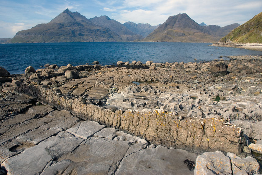
Over the intervening period between the Paleogene and the present the overlying colcanoes and lavas have been eroded to reveal the magma chambers whose Gabbros now form the Cuillens.
The Skye Gabbros are also broken up by the intrusion of fine-grained dykes and sills which effect they way in which the rock weathers, creating notches in ridge profiles and up-standing walls and blades, such as the Inaccessible Pinnacle of Sgurr Dearg. (see Stephenson, D. and Merritt, J., 2006 Skye: A Landscape Fashioned by Geology, Scottish Natural Heritage, p.13-14.).
The Red Hills that lie adjacent to the Cuillins are formed from granite. Granite intrusions are formed when the earth crust melts and rises through the surrounding rock. Whereas basalts and Gabbros are magmas that arise from beneath the earth's crust.
Motlen magma can be at a temperature of 1200 degrees C and can take millions of years to cool when it is in large chambers at depth. The rocks surrounding the chambers are also powerfully affected (metamorphosised) as they are melted, baked, and altered.
The Cuillins had their own independent ice cap in the last glaciation (12,500-11,500 years ago. This short glacial period swept away many of the features of the previous glacial cycles.
In contrast to the Lyngen Alps, which are formed from a gabbro nappe that has been heaved perhaps 150km over basement rocks by tectonic forces, the Cuillin gabbro is both much younger than that of Lyngen and has remained in situ.
I would imagine/suggest/propose that this might lead to different characteristics in the two gabbro masses. The Lyngen one might be more fragmented, faulted and folded and thrust up at an angle whereas the Cuillin gabbro may have been more intruded into by rising basalt dykes and sills (although is there really any difference between them as slowly colling subterranean magma masses as considerable depth within the Earth's crust?).
To next page:
For other glaciation pages see
New Zealand: The Southern Alps and Glaciers